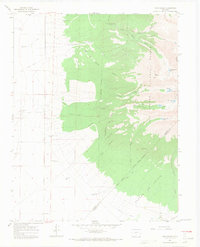
1965 Map of Twin Peaks
USGS Topo · Published 1968About this map
Twin Peaks rises above the transition from the high San Luis Valley floor into the high elevations of the Rio Grande National Forest during the mid-1960s. This survey of the Sangre de Cristo Range captures a landscape defined by water management and mineral prospects, featuring isolated infrastructure like the Swab Mine and several water control points including the Tobin Creek Dam and Holbrook Creek Dam. The presence of the Pioneer Urraca Cem near Urraca Creek suggests the enduring legacy of early settlers in this high-altitude environment.
Find a feature on this map
40 named features on this map. Tap any name to fly to it.
Don’t see what you’re looking for? This feature index may not catch every label — zoom into the map to look around manually.
Map Details
Editions of this 1965 Twin Peaks Map
3 editions found

Other maps of this area

1889 · Huerfano Park
USGS Topo · 1:125,000

1892 · Huerfano Park
USGS Topo · 1:125,000

1954 · Trinidad
USGS Topo · 1:250,000

1955 · Trinidad
USGS Topo · 1:250,000

1958 · Trinidad
USGS Topo · 1:250,000

1959 · Trinidad
USGS Topo · 1:250,000

1965 · Medano Ranch
USGS Topo · 1:24,000

1965 · Blanca
USGS Topo · 1:24,000

1965 · Zapata Ranch
USGS Topo · 1:24,000

1965 · Baldy
USGS Topo · 1:24,000