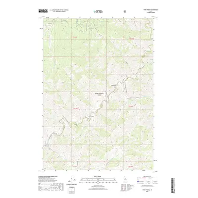
2020 Map of Twin Springs
USGS Topo · Published 2020About this map
Twin Springs serves as a central point of interest in this mountain landscape where the North Fork Boise River meets a network of steep drainages. Located within the Boise National Forest, the map illustrates a terrain defined by significant vertical relief, from the heights of Bald Mtn and Thorn Creek Butte to the river floor at River Landing. The presence of Hot Springs near the main settlement suggests the geothermal character of the area, which has long influenced local activity and land use. Transportation is anchored by the Atlanta Road, which snakes through the canyon following the river's course. Recreational and natural features are prominent, including the William Pogue National Recreation Trail and various named gulches like Logging Gulch and Slide Gulch, which provide insight into the historical industry and geological events that shaped these slopes.
Find a feature on this map
29 named features on this map. Tap any name to fly to it.
Don’t see what you’re looking for? This feature index may not catch every label — zoom into the map to look around manually.
Map Details
Editions of this 2020 Twin Springs Map
This is the sole edition of this map. No revisions or reprints were ever made.
Other maps of this area

1894 · Idaho Basin
USGS Topo · 1:125,000

1955 · Hailey
USGS Topo · 1:250,000

1957 · Idaho City
USGS Topo · 1:24,000

1959 · Hailey
USGS Topo · 1:250,000

1962 · Hailey
USGS Topo · 1:250,000
1964 · Prairie
USGS Topo · 1:24,000

1964 · Sheep Creek
USGS Topo · 1:24,000

1964 · Twin Springs
USGS Topo · 1:24,000
1964 · Long Gulch
USGS Topo · 1:24,000
1969 · Arrowrock Reservoir NE
USGS Topo · 1:24,000