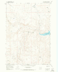
1967 Map of Twin Springs
USGS Topo · Published 1971About this map
Lake Owyhee reaches into the eastern edge of this desert landscape, its waters filling the narrow basalt-lined canyons of Malheur County during the late 1960s. The region is defined by a sparse network of vital water sources, including Lower Burnt Spring, Twin Springs, and Dead Horse Spring, which served as critical landmarks for ranchers and travelers moving through the arid high desert. The topography is dominated by massive volcanic features like Sourdough Mtn and the Dry Creek Buttes, while low-lying areas like Sand Hollow and Sourdough Basin provide a stark contrast to the surrounding peaks. A solitary jeep trail and the path over Hammond Hill represent the minimal human infrastructure, connecting these remote springs and reservoirs like Dry Creek Buttes Reservoir across a landscape primarily shaped by erosion and drainage through Freezeout Creek and Dry Creek.
Find a feature on this map
19 named features on this map. Tap any name to fly to it.
Don’t see what you’re looking for? This feature index may not catch every label — zoom into the map to look around manually.
Map Details
Editions of this 1967 Twin Springs Map
2 editions found
Other maps of this area

1906 · Mitchell Butte
USGS Topo · 1:125,000

1955 · Boise
USGS Topo · 1:250,000

1958 · Boise
USGS Topo · 1:250,000

1962 · Boise
USGS Topo · 1:250,000

1967 · Pelican Point
USGS Topo · 1:24,000
1967 · Sourdough Spring
USGS Topo · 1:24,000
1967 · The Elbow
USGS Topo · 1:24,000

1967 · Twin Springs
USGS Topo · 1:24,000
1967 · Grassy Mtn
USGS Topo · 1:24,000

1967 · Quartz Mtn Basin
USGS Topo · 1:24,000