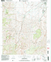
2004 Map of Two Bar Mountain
USGS Topo · Published 2007About this map
Two Bar Mountain and the high desert ridges of the Superstition Wilderness dominate this Arizona landscape on the border of Gila and Maricopa counties. Within the Tonto National Forest, the map captures a network of remote ranching outposts and springs, such as Black Brush Headquarters, the Schoolhouse, and USLM Spring Creek Ranch. The northeastern corner transitions into the residential development of Roosevelt Lake Estates near the Roosevelt Post Office, showing the contrast between organized settlements and the expansive backcountry marked by features like Nonesuch Rocks and Gunsight Gap. Drainages like Campaign Creek and Wildcat Creek cut through the terrain, serving as vital landmarks for the ranching operations at Cross P Ranch and surrounding grazing lands.
Find a feature on this map
49 named features on this map. Tap any name to fly to it.
Don’t see what you’re looking for? This feature index may not catch every label — zoom into the map to look around manually.
Map Details
Editions of this 2004 Two Bar Mountain Map
This is the sole edition of this map. No revisions or reprints were ever made.
Other maps of this area

1900 · Florence
USGS Topo · 1:125,000

1901 · Globe
USGS Topo · 1:62,500

1902 · Globe
USGS Topo · 1:62,500

1902 · Florence
USGS Topo · 1:125,000

1907 · Roosevelt
USGS Topo · 1:125,000

1909 · Four Peaks
USGS Topo · 1:125,000

1912 · Roosevelt
USGS Topo · 1:125,000

1922 · Chrysotile
USGS Topo · 1:125,000

1945 · Inspiration
USGS Topo · 1:24,000

1947 · Inspiration
USGS Topo · 1:24,000