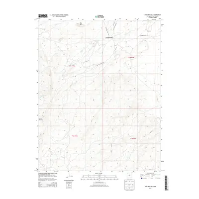
2013 Map of Two Grey Hills
USGS Topo · Published 2013About this map
Two Grey Hills serves as a primary landmark in this high-desert landscape of San Juan County, positioned between the striking heights of the Chuska Mountains and Grey Mesa. The settlement and its surrounding terrain are defined by an intricate network of tribal roads, including Indian Service Route 5004 and Indian Service Route 192, which trace the contours of the land. Water, though seasonal, has shaped the topography through numerous drainage systems like Captain Tom Wash, To-dil-hil Wash, and Tuntsa Wash. Small but vital water sources such as Mike Spring and Mormon Spring appear on the sheet, indicating the critical nature of these points in a region where geography and resource access are deeply linked. The map illustrates a sparse but deliberate human footprint across the vast New Mexico plateau.
Find a feature on this map
22 named features on this map. Tap any name to fly to it.
Don’t see what you’re looking for? This feature index may not catch every label — zoom into the map to look around manually.
Map Details
Editions of this 2013 Two Grey Hills Map
This is the sole edition of this map. No revisions or reprints were ever made.
Other maps of this area

1889 · Chaco
USGS Topo · 1:250,000

1892 · Chaco
USGS Topo · 1:250,000

1927 · Sulphur Spring
USGS Topo · 1:96,000

1928 · Kirtland
USGS Topo · 1:125,000

1932 · Kirtland
USGS Topo · 1:125,000

1953 · Sanostee
USGS Topo · 1:62,500

1954 · Shiprock
USGS Topo · 1:250,000

1958 · Shiprock
USGS Topo · 1:250,000

1959 · Shiprock
USGS Topo · 1:250,000
1966 · Sheep Springs
USGS Topo · 1:24,000
Featured Places
- Shiprock Agency
- Kin Łizhin, Shiprock Agency
- Two Grey Hills, Shiprock Agency
- San Juan County, NM
- United States