
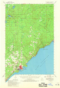
1957 Map of Two Harbors
USGS Topo · Published 1958About this map
Two Harbors serves as the industrial and maritime hub of this North Shore landscape, where the Duluth Missabe and Iron Range RR meets the waters of Agate Bay and Burlington Bay. The town center is densely detailed, showing the City Hall, the Fairground, and the local Johnson School. Just offshore, a Lighthouse and Light guide vessels navigating Lake Superior.
Find a feature on this map
56 named features on this map. Tap any name to fly to it.
Don’t see what you’re looking for? This feature index may not catch every label — zoom into the map to look around manually.
Map Details
Editions of this 1957 Two Harbors Map
2 editions found
Other maps of this area

1943 · Port Wing
USGS Topo · 1:48,000

1946 · Port Wing
USGS Topo · 1:48,000

1953 · Knife River
USGS Topo · 1:24,000

1953 · Whyte
USGS Topo · 1:62,500

1953 · Ashland
USGS Topo · 1:250,000

1954 · Mc Carthy Creek
USGS Topo · 1:24,000

1954 · Silver Bay
USGS Topo · 1:62,500

1954 · Two Harbors
USGS Topo · 1:250,000

1956 · Split Rock Point
USGS Topo · 1:24,000

1956 · King Lake
USGS Topo · 1:24,000