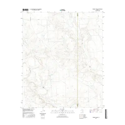
2016 Map of Twomile Creek
USGS Topo · Published 2016About this map
The Salt Fork Brazos River winds through the southwestern portion of this West Texas landscape, cutting across the arid terrain of the Garza and Kent county line. The topography is defined by significant drainage systems, where seasonal water sources like Red Arroyo and Twomile Cr feed into the larger river valleys. Evidence of ranching and land management in the mid-2010s is visible through numerous water collection points, including Twomile Tank, Horse Hollow Tank, and Kay Tank. The map also captures the local relief of Horse Hollow and Chimney Cr to the north. Transportation is limited to a sparse grid of rural routes such as Co RD 128 and Co RD 395, illustrating the open, low-density character of this cattle country.
Find a feature on this map
14 named features on this map. Tap any name to fly to it.
Don’t see what you’re looking for? This feature index may not catch every label — zoom into the map to look around manually.
Map Details
Editions of this 2016 Twomile Creek Map
This is the sole edition of this map. No revisions or reprints were ever made.
Other maps of this area

1954 · Lubbock
USGS Topo · 1:250,000

1962 · Twomile Creek
USGS Topo · 1:24,000

1962 · Smith Tank
USGS Topo · 1:24,000

1966 · Kalgary
USGS Topo · 1:24,000

1967 · Spur NW
USGS Topo · 1:24,000

1968 · Spur SW
USGS Topo · 1:24,000

1969 · Verbena
USGS Topo · 1:24,000

1969 · Cottonwood Creek
USGS Topo · 1:24,000
1969 · Justiceburg NW
USGS Topo · 1:24,000

1969 · T-O Creek
USGS Topo · 1:24,000