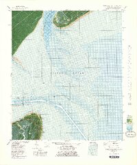
1978 Map of Tybee Island North
USGS Topo · Published 1978About this map
The maritime gateway to the Georgia coast is captured here in the late 1970s, dominated by the strategic waters of Tybee Roads and the mouth of the Savannah River. The map provides an orthophoto view of the northern tip of Tybee Island, where the historic Fort Screven (Tybee Museum) and the Old Lighthouse stand as sentinels over the shifting sands. Significant coastal management is evident through the notation of Beach Renourished 1976, reflecting the ongoing efforts to protect this vulnerable shoreline from the Atlantic Ocean.
Find a feature on this map
33 named features on this map. Tap any name to fly to it.
Don’t see what you’re looking for? This feature index may not catch every label — zoom into the map to look around manually.
Map Details
Editions of this 1978 Tybee Island North Map
This is the sole edition of this map. No revisions or reprints were ever made.
Other maps of this area

1920 · Wassaw Sound
USGS Topo · 1:62,500

1920 · Hilton Head
USGS Topo · 1:62,500

1920 · Bluffton
USGS Topo · 1:62,500

1945 · Bluffton
USGS Topo · 1:62,500

1945 · Hilton Head
USGS Topo · 1:62,500

1945 · Wassaw Sound
USGS Topo · 1:62,500

1946 · Brunswick
USGS Topo · 1:250,000

1947 · Savannah
USGS Topo · 1:250,000

1948 · Brunswick
USGS Topo · 1:250,000

1948 · Savannah
USGS Topo · 1:250,000