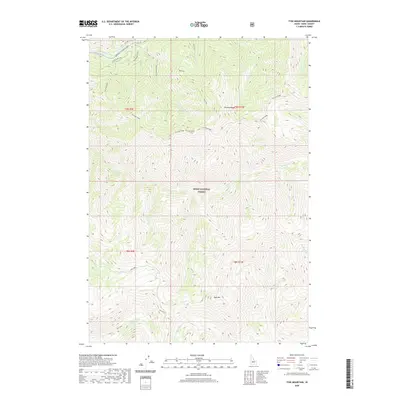
2020 Map of Tyee Mountain
USGS Topo · Published 2020About this map
Boise National Forest dominates this high-altitude landscape in Boise County, defined by a series of steep drainage basins and prominent ridges. The northern edge follows the course of the South Fork Payette River, where the Idaho City-Stanley-SH 21 provides the primary corridor for movement through these mountains. Elevations climb rapidly south of the river toward the crest of Ten Mile Ridge, which serves as a major topographical spine for the quadrangle.
Find a feature on this map
24 named features on this map. Tap any name to fly to it.
Don’t see what you’re looking for? This feature index may not catch every label — zoom into the map to look around manually.
Map Details
Editions of this 2020 Tyee Mountain Map
This is the sole edition of this map. No revisions or reprints were ever made.
Other maps of this area

1891 · Bear Valley
USGS Topo · 1:125,000

1893 · Bear Valley
USGS Topo · 1:125,000

1894 · Rocky Bar
USGS Topo · 1:125,000

1955 · Hailey
USGS Topo · 1:250,000

1957 · Challis
USGS Topo · 1:250,000

1959 · Hailey
USGS Topo · 1:250,000

1960 · Challis
USGS Topo · 1:250,000

1962 · Hailey
USGS Topo · 1:250,000

1963 · Challis
USGS Topo · 1:250,000
1972 · Bear River
USGS Topo · 1:24,000