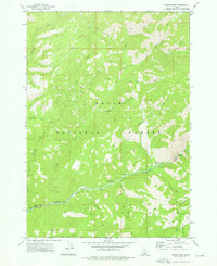
1972 Map of Bear River
USGS Topo · Published 1976About this map
The Boise National Forest dominates this topographic study, revealing a landscape defined by the deep drainage of the North Fork Boise River. In the early 1970s, this area served as a critical corridor for backcountry access, evidenced by the network of Jeep Trails and Pack Trails that wind through the timbered slopes. The map captures the boundary between Boise Co and Elmore Co, tracing a line through the high country where numerous tributaries like Steamboat Creek and Hunter Creek converge on the main river valley.
Find a feature on this map
33 named features on this map. Tap any name to fly to it.
Don’t see what you’re looking for? This feature index may not catch every label — zoom into the map to look around manually.
Map Details
Editions of this 1972 Bear River Map
This is the sole edition of this map. No revisions or reprints were ever made.
Other maps of this area

1891 · Bear Valley
USGS Topo · 1:125,000

1893 · Bear Valley
USGS Topo · 1:125,000

1894 · Idaho Basin
USGS Topo · 1:125,000

1894 · Rocky Bar
USGS Topo · 1:125,000

1909 · Garden Valley
USGS Topo · 1:125,000

1955 · Hailey
USGS Topo · 1:250,000

1957 · Challis
USGS Topo · 1:250,000

1959 · Hailey
USGS Topo · 1:250,000

1960 · Challis
USGS Topo · 1:250,000

1962 · Hailey
USGS Topo · 1:250,000