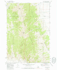
1969 Map of Tyler Peak
USGS Topo · Published 1988About this map
The Lemhi Range dominates this late-1960s survey, marking a high-elevation divide where Challis National Forest meets Targhee National Forest. The landscape is defined by its deep drainages and prominent peaks, including Saddle Mountain and Tyler Peak. Human presence is minimal, evidenced primarily by a high-altitude Jeep Tr winding through Tyler Canyon in the northern portion of the quadrangle.
Find a feature on this map
29 named features on this map. Tap any name to fly to it.
Don’t see what you’re looking for? This feature index may not catch every label — zoom into the map to look around manually.
Map Details
Editions of this 1969 Tyler Peak Map
2 editions found
Other maps of this area

1955 · Dubois
USGS Topo · 1:250,000

1955 · Idaho Falls
USGS Topo · 1:250,000

1957 · Diamond Peak
USGS Topo · 1:62,500

1958 · Dubois
USGS Topo · 1:250,000

1958 · Idaho Falls
USGS Topo · 1:250,000

1969 · Little Lost River Sinks
USGS Topo · 1:24,000

1969 · Eightmile Canyon
USGS Topo · 1:24,000

1969 · Richard Butte
USGS Topo · 1:24,000

1969 · Tyler Peak
USGS Topo · 1:24,000

1969 · Howe
USGS Topo · 1:24,000