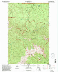
1995 Map of Tyler Peak
USGS Topo · Published 1997About this map
The Buckhorn Wilderness and Olympic National Forest dominate this high-elevation landscape as it was documented in the mid-1990s. The terrain is defined by dramatic ridgelines such as Gray Wolf Ridge and Deer Ridge, where the complex network of federal lands converges. The presence of numerous designated shelters and sites like Three Forks Shelter, Slab Camp, and Grey Wolf Camp reflects a landscape managed for primitive recreation and backcountry access. Significant water systems, including the Gray Wolf River and Cameron Creek, have carved deep valleys through the peaks.
Find a feature on this map
38 named features on this map. Tap any name to fly to it.
Don’t see what you’re looking for? This feature index may not catch every label — zoom into the map to look around manually.
Map Details
Editions of this 1995 Tyler Peak Map
This is the sole edition of this map. No revisions or reprints were ever made.
Other maps of this area

1918 · Port Angeles
USGS Topo · 1:62,500

1938 · Mt Constance
USGS Topo · 1:125,000

1938 · Dungeness
USGS Topo · 1:62,500

1939 · Dungeness
USGS Topo · 1:62,500

1941 · Port Angeles
USGS Topo · 1:62,500

1944 · Mt. Angeles
USGS Topo · 1:62,500

1946 · Mt. Angeles
USGS Topo · 1:62,500

1946 · Tyler Peak
USGS Topo · 1:62,500

1948 · Tyler Peak
USGS Topo · 1:62,500

1956 · Sequim
USGS Topo · 1:24,000