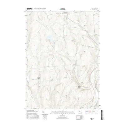
2016 Map of Tyner
USGS Topo · Published 2016About this map
The Chenango River valley defines the eastern edge of this Central New York landscape, where the settlements of Tyner, Smithville Center, and East McDonough are connected by a network of rural roads such as McDonough Rd and Co Rd 3. The terrain is marked by numerous family-named landmarks and water bodies, including Lake Ludlow and Warn Lake, alongside significant wetland areas like Corbin Swamp and Spruce Swamp. Genealogists will find this particular survey especially useful for its high density of small family burial grounds, including the Ten Broeck Cem, Cowles Cem, and Beardsley Cem. These sites, often located near former homesteads along roads like Hoben Rd and Corbin Rd, provide a clear view of the area's 19th-century settlement patterns as they persisted into the early 21st century.
Find a feature on this map
74 named features on this map. Tap any name to fly to it.
Don’t see what you’re looking for? This feature index may not catch every label — zoom into the map to look around manually.
Map Details
Editions of this 2016 Tyner Map
This is the sole edition of this map. No revisions or reprints were ever made.
Other maps of this area

1902 · Coventry
USGS Topo · 1:62,500

1903 · Norwich
USGS Topo · 1:62,500

1904 · Greene
USGS Topo · 1:62,500

1904 · Oxford
USGS Topo · 1:62,500

1904 · Pitcher
USGS Topo · 1:62,500

1943 · Norwich
USGS Topo · 1:24,000

1943 · East Pharsalia
USGS Topo · 1:24,000

1943 · Pitcher
USGS Topo · 1:24,000
1943 · Norwich
USGS Topo · 1:62,500
1944 · Pitcher
USGS Topo · 1:31,680