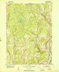
1951 Map of Tyner
USGS Topo · Published 1951About this map
Lake Ludlow and the winding Ludlow Creek anchor this central New York landscape, which is defined by a dense network of country roads and family-named cemeteries. In the mid-20th century, the Chenango River valley remained a critical corridor for transportation, featuring the Delaware Lackawanna and Western railroad and an Abandoned Canal running parallel to the water. This coexistence of active rail and defunct canal infrastructure reflects the evolving transportation technology of the region. Scattered throughout the townships of McDonough, Smithville, and Preston are several historic hamlets including Tyner, East McDonough, and Smithville Center. Genealogists will find a wealth of specific local landmarks, from the Windham Sch to numerous small burial grounds such as Stafford Cem, Corbin Cem, and Pond Cem, many of which represent early pioneer family plots situated near crossroads like Ingraham Corners.
Find a feature on this map
44 named features on this map. Tap any name to fly to it.
Don’t see what you’re looking for? This feature index may not catch every label — zoom into the map to look around manually.
Map Details
Editions of this 1951 Tyner Map
This is the sole edition of this map. No revisions or reprints were ever made.
Other maps of this area

1902 · Coventry
USGS Topo · 1:62,500

1903 · Norwich
USGS Topo · 1:62,500

1904 · Greene
USGS Topo · 1:62,500

1904 · Oxford
USGS Topo · 1:62,500

1904 · Pitcher
USGS Topo · 1:62,500

1943 · Norwich
USGS Topo · 1:24,000

1943 · East Pharsalia
USGS Topo · 1:24,000

1943 · Pitcher
USGS Topo · 1:24,000
1943 · Norwich
USGS Topo · 1:62,500
1944 · Pitcher
USGS Topo · 1:31,680