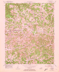
1953 Map of Tyner
USGS Topo · Published 1972About this map
Tyner and Annville serve as central nodes in this 1950s study of Jackson County, where the landscape is defined by a dense network of branches and forks within the Cumberland National Forest. The map documents a rural society deeply tied to its land, shown through numerous family-named landmarks and local institutions like the Tyner High School and Welchburg School. Settlements such as Bond and Egypt are connected by winding valley roads, while the presence of a Strip Mine and the Indefinite Boundary near the Clay County line hint at the region's industrial and administrative complexities. Genealogists will find significant value in the distribution of small burial grounds, including the Morris Cemetery and Farris Cemetery, alongside community spiritual centers like the Blooming Grove Church and Terrell Creek Tabernacle.
Find a feature on this map
56 named features on this map. Tap any name to fly to it.
Don’t see what you’re looking for? This feature index may not catch every label — zoom into the map to look around manually.
Map Details
Editions of this 1953 Tyner Map
2 editions found
Other maps of this area

1891 · Manchester
USGS Topo · 1:125,000

1893 · London
USGS Topo · 1:125,000

1897 · London
USGS Topo · 1:125,000

1952 · Portersburg
USGS Topo · 1:24,000

1952 · Manchester
USGS Topo · 1:24,000

1952 · London
USGS Topo · 1:24,000

1953 · Mc Kee
USGS Topo · 1:24,000

1953 · Sandgap
USGS Topo · 1:24,000

1953 · Tyner
USGS Topo · 1:24,000

1953 · Parrot
USGS Topo · 1:24,000