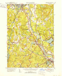
1950 Map of Tyngsboro
USGS Topo · Published 1952About this map
The Merrimack River serves as the central artery for this mid-century portrait of the Massachusetts-New Hampshire borderlands, where industrial expansion and academic institutions meet the colonial-era geography of Dunstable. The landscape is punctuated by numerous family-named corners such as Swan Corner and Hayward Corner, reflecting a long-standing pattern of dispersed local settlements. In the north, Nashua shows significant development around Rivier College and the Nashua Country Club, while the river's path is closely followed by the Boston and Maine Railroad and the Daniel Webster Highway.
Find a feature on this map
104 named features on this map. Tap any name to fly to it.
Don’t see what you’re looking for? This feature index may not catch every label — zoom into the map to look around manually.
Map Details
Editions of this 1950 Tyngsboro Map
3 editions found
Other maps of this area

1886 · Lowell
USGS Topo · 1:62,500

1893 · Lowell
USGS Topo · 1:62,500

1893 · Groton
USGS Topo · 1:62,500

1905 · Manchester
USGS Topo · 1:62,500

1906 · Milford
USGS Topo · 1:62,500

1918 · Lowell
USGS Topo · 1:62,500

1921 · Lowell
USGS Topo · 1:62,500

1931 · Lowell
USGS Topo · 1:48,000

1931 · Groton
USGS Topo · 1:48,000

1935 · Ayer
USGS Topo · 1:24,000