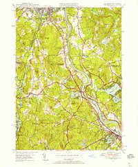
1950 Map of Tyngsboro
USGS Topo · Published 1958About this map
The Merrimack River snakes through the center of this mid-century landscape, anchoring a region defined by established river-valley industry and expanding educational institutions. In Nashua, the campus of Rivier College and St Marie Convent overlook the valley, while the Boston and Maine railroad tracks parallel the water, serving the industrial hubs at North Chelmsford and beyond. The map highlights numerous family-named corners and hills, such as Hayward Corner and Scribner Hill, which reflect the area's deep-rooted colonial genealogy. In Dunstable, the presence of the Old Dunstable Cem and Central Cem provides critical points for genealogical research. To the west, the rugged terrain around Flat Rock Quarry and Fox Ledge contrasts with the recreational development near Mascopic Lake and the Vesper Country Club on Tyngs Island.
Find a feature on this map
88 named features on this map. Tap any name to fly to it.
Don’t see what you’re looking for? This feature index may not catch every label — zoom into the map to look around manually.
Map Details
Editions of this 1950 Tyngsboro Map
3 editions found
Other maps of this area

1886 · Lowell
USGS Topo · 1:62,500

1893 · Lowell
USGS Topo · 1:62,500

1893 · Groton
USGS Topo · 1:62,500

1905 · Manchester
USGS Topo · 1:62,500

1906 · Milford
USGS Topo · 1:62,500

1918 · Lowell
USGS Topo · 1:62,500

1921 · Lowell
USGS Topo · 1:62,500

1931 · Lowell
USGS Topo · 1:48,000

1931 · Groton
USGS Topo · 1:48,000

1935 · Ayer
USGS Topo · 1:24,000