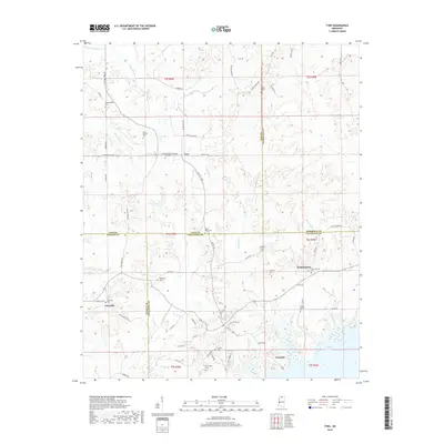
2018 Map of Tyro
USGS Topo · Published 2018About this map
Tyro sits at a crossroads of Lafayette, Tate, and Marshall counties, characterizing the rural landscape of northern Mississippi. The region is defined by a network of creeks and improved waterways, such as James Wolf Canal and Greasy Cr, which drain toward the extensive waters of Sardis Lake in the southeast. For researchers and genealogists, this documentation is particularly valuable for its density of family and community landmarks. Numerous burial sites including Free Springs Cem, Waldrip Cem, and Mount Pelyn Cem are scattered across the terrain, often located near small settlements like Harmontown and Glenville. The map captures the interface between managed hydraulic features and traditional rural communities, offering a clear record of the area's roads and land divisions as they existed in the late twenty-first century.
Find a feature on this map
77 named features on this map. Tap any name to fly to it.
Don’t see what you’re looking for? This feature index may not catch every label — zoom into the map to look around manually.
Map Details
Editions of this 2018 Tyro Map
This is the sole edition of this map. No revisions or reprints were ever made.
Other maps of this area

1940 · Oxford
USGS Topo · 1:62,500

1943 · Oxford
USGS Topo · 1:62,500

1944 · Senatobia
USGS Topo · 1:62,500

1944 · Tyro
USGS Topo · 1:62,500

1952 · Sardis
USGS Topo · 1:62,500

1953 · Sardis
USGS Topo · 1:62,500

1956 · Tupelo
USGS Topo · 1:250,000

1958 · Tupelo
USGS Topo · 1:250,000
1971 · Marianna
USGS Topo · 1:24,000

1971 · Wyatte
USGS Topo · 1:24,000