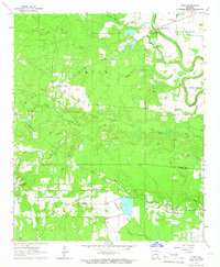
1964 Map of Tyro
USGS Topo · Published 1966About this map
Tyro and Garrett Bridge anchor this 1964 topographic study of southeastern Arkansas, where the landscape transitions from the wooded uplands of Smith Hill and Spring Hill to the fertile bottomlands of the Bartholomew Bayou. The map illustrates a rural economy defined by local timber and transport, evidenced by a Lookout Tower overlooking the western forests and a complex network of creeks like Ables Creek and Prairie Creek that drain toward the bayou. Significant for local historians, the sheet identifies established community centers such as Florence and Green Mount, alongside numerous rural institutions including Oak Grove Cem & Ch and Pleasant Ridge Ch. The presence of several Gravel Pits near Coleman and the expansive Touchstone Prairie highlight the distinct geological and environmental zones meeting along the Lincoln and Drew County line.
Find a feature on this map
34 named features on this map. Tap any name to fly to it.
Don’t see what you’re looking for? This feature index may not catch every label — zoom into the map to look around manually.
Map Details
Editions of this 1964 Tyro Map
This is the sole edition of this map. No revisions or reprints were ever made.
Other maps of this area

1935 · Feenyville
USGS Topo · 1:62,500

1935 · Cominto
USGS Topo · 1:62,500

1935 · Rotan
USGS Topo · 1:62,500

1953 · Greenwood
USGS Topo · 1:250,000

1956 · Greenwood
USGS Topo · 1:250,000

1960 · Selma
USGS Topo · 1:24,000

1960 · Collins NW
USGS Topo · 1:24,000

1960 · Collins
USGS Topo · 1:62,500
1964 · Avery
USGS Topo · 1:24,000
1964 · Gourd
USGS Topo · 1:24,000