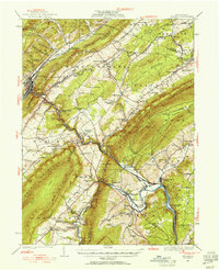
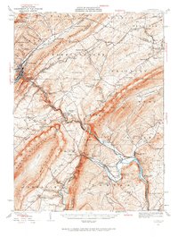
1929 Map of Tyrone
USGS Topo · Published 1954About this map
The industrial and agricultural geography of Central Pennsylvania is clearly defined here by the confluence of the Little Juniata River and the Frankstown Branch. The Pennsylvania RR corridor serves as the primary artery for the region, anchoring settlements like Tyrone and Alexandria. In the shadows of Bald Eagle Mountain and Tussey Mountain, the landscape reveals an earlier era of iron production, evidenced by the presence of Union Furnace and Pennsylvania Furnace. These sites, along with the scattered one-room schoolhouses such as Cabin Ford Sch and Mountain Orchard Sch, illustrate a community structured around valley floor resource extraction and highland rural life.
Find a feature on this map
127 named features on this map. Tap any name to fly to it.
Don’t see what you’re looking for? This feature index may not catch every label — zoom into the map to look around manually.
Map Details
Editions of this 1929 Tyrone Map
6 editions found

Other maps of this area

1901 · Huntingdon
USGS Topo · 1:62,500

1902 · Hollidaysburg
USGS Topo · 1:62,500

1903 · Hollidaysburg
USGS Topo · 1:62,500

1903 · Houtzdale
USGS Topo · 1:62,500

1904 · Huntingdon
USGS Topo · 1:62,500

1905 · Houtzdale
USGS Topo · 1:62,500

1908 · Bellefonte
USGS Topo · 1:62,500

1909 · Bellefonte
USGS Topo · 1:62,500

1919 · Menno
USGS Topo · 1:62,500

1920 · Altoona
USGS Topo · 1:62,500