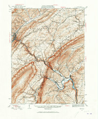
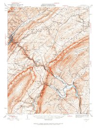
1929 Map of Tyrone
USGS Topo · Published 1973About this map
The Little Juniata River carves through the ridge-and-valley landscape of Central Pennsylvania in this late 1920s survey. The industrial heritage of the region is evident in the cluster of ironworks and furnace settlements, including Huntingdon Furnace, Union Furnace, and Pennsylvania Furnace. These sites, along with the Frankstown Branch Pennsylvania Canal following the Juniata River, reflect an era when local resources fueled early American industry. The map captures the density of small-scale rural infrastructure through a extensive network of schoolhouses like Mountain Orchard Sch, Hickory Bottom Sch, and Cabin Ford Sch. Transport is dominated by the Pennsylvania RR, which follows the river valley through Tyrone and Birmingham, connecting the iron-rich ridges of Bald Eagle Mountain and Tussey Mountain with the broader state commerce.
Find a feature on this map
120 named features on this map. Tap any name to fly to it.
Don’t see what you’re looking for? This feature index may not catch every label — zoom into the map to look around manually.
Map Details
Editions of this 1929 Tyrone Map
6 editions found

Other maps of this area

1901 · Huntingdon
USGS Topo · 1:62,500

1902 · Hollidaysburg
USGS Topo · 1:62,500

1903 · Hollidaysburg
USGS Topo · 1:62,500

1903 · Houtzdale
USGS Topo · 1:62,500

1904 · Huntingdon
USGS Topo · 1:62,500

1905 · Houtzdale
USGS Topo · 1:62,500

1908 · Bellefonte
USGS Topo · 1:62,500

1909 · Bellefonte
USGS Topo · 1:62,500

1919 · Menno
USGS Topo · 1:62,500

1920 · Altoona
USGS Topo · 1:62,500