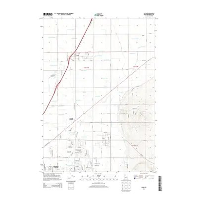
2013 Map of Ucon
USGS Topo · Published 2013About this map
Idaho Falls anchors the southwest corner of this landscape, where the urban grid gives way to an intricate system of agricultural irrigation. The area is defined by a dense network of man-made waterways, including the Farmers Friend Canal, Centerville Canal, and Anderson Canal, which distribute water across the eastern Snake River Plain. Small rural clusters like Ucon, Iona, and Lincoln illustrate the pattern of development around these crucial water sources. The transition from the developed city center to the surrounding agricultural lands is marked by features like Beachs Corner and the Lincoln Cemetery. To the east, the terrain begins to rise toward the foothills, where the Hillside Canal and Gardner Canal navigate more complex topography. This survey captures a moment of modern growth in Bonneville County, showing how historical irrigation infrastructure continues to shape the expansion of these Idaho communities.
Find a feature on this map
78 named features on this map. Tap any name to fly to it.
Don’t see what you’re looking for? This feature index may not catch every label — zoom into the map to look around manually.
Map Details
Editions of this 2013 Ucon Map
This is the sole edition of this map. No revisions or reprints were ever made.
Other maps of this area

1924 · Ammon
USGS Topo · 1:62,500

1948 · Rigby
USGS Topo · 1:24,000

1948 · Lewisville
USGS Topo · 1:24,000

1948 · Idaho Falls North
USGS Topo · 1:24,000

1948 · Idaho Falls South
USGS Topo · 1:24,000

1948 · Ucon
USGS Topo · 1:24,000

1949 · Ucon
USGS Topo · 1:24,000

1949 · Idaho Falls North
USGS Topo · 1:24,000

1949 · Rigby
USGS Topo · 1:24,000

1949 · Lewisville
USGS Topo · 1:24,000