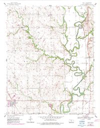
1955 Map of Udall
USGS Topo · Published 1983About this map
Udall and the surrounding southern Kansas prairie are defined by the winding course of the Walnut River and its many tributaries, including Maple Creek, Polecat Creek, and Rock Creek. This mid-century landscape is etched with the markers of a rural community's daily life, from the Red Bud Sch and Olive Sch to several country cemeteries such as Star Valley Cem. The Old Indian Boundary cuts across the northern townships of Richland and Douglass, serving as a silent reminder of earlier territorial divisions. Along the eastern edge, the Atchison Topeka and Santa Fe railroad corridor runs through Rock, supporting the local economy alongside scattered Oil Wells and a Quarry. The concentration of small schools and churches like Walnut Valley Ch illustrates the decentralized settlement pattern characteristic of Cowley County during this era.
Find a feature on this map
32 named features on this map. Tap any name to fly to it.
Don’t see what you’re looking for? This feature index may not catch every label — zoom into the map to look around manually.
Map Details
Editions of this 1955 Udall Map
2 editions found
Other maps of this area

1888 · Eldorado
USGS Topo · 1:125,000

1889 · Burden
USGS Topo · 1:125,000

1889 · Wichita
USGS Topo · 1:125,000

1890 · Wellington
USGS Topo · 1:125,000

1894 · Wichita
USGS Topo · 1:125,000

1955 · Udall
USGS Topo · 1:24,000

1955 · Rose Hill
USGS Topo · 1:24,000

1955 · Mulvane
USGS Topo · 1:24,000

1955 · Douglass
USGS Topo · 1:24,000

1955 · Wichita
USGS Topo · 1:250,000