
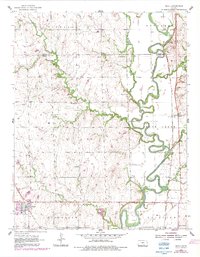
1955 Map of Udall
USGS Topo · Published 1956About this map
Udall and the surrounding Cowley County countryside are defined by a landscape transitioning between agricultural fields and the meandering Walnut River. The mid-1950s terrain is dotted with small-scale rural infrastructure, including Red Bud Sch and Olive Sch, alongside community anchors like Star Valley Cem and Brookshire Cem. The Atchison Topeka and Santa Fe railroad cuts a north-south path through Rock, supporting the regional movement of goods and people. Local industry is visible through numerous Oil Wells and a Quarry near the riverbanks. An Old Indian Boundary line persists in the survey, marking a historical division that predates the modern township grid. This period shows the area prior to significant modern infrastructure changes, preserving the locations of family-named landmarks and small country churches like Walnut Valley Ch.
Find a feature on this map
29 named features on this map. Tap any name to fly to it.
Don’t see what you’re looking for? This feature index may not catch every label — zoom into the map to look around manually.
Map Details
Editions of this 1955 Udall Map
2 editions found
Other maps of this area

1888 · Eldorado
USGS Topo · 1:125,000

1889 · Burden
USGS Topo · 1:125,000

1889 · Wichita
USGS Topo · 1:125,000

1890 · Wellington
USGS Topo · 1:125,000

1894 · Wichita
USGS Topo · 1:125,000

1955 · Rose Hill
USGS Topo · 1:24,000

1955 · Mulvane
USGS Topo · 1:24,000

1955 · Douglass
USGS Topo · 1:24,000

1955 · Wichita
USGS Topo · 1:250,000

1958 · Wichita
USGS Topo · 1:250,000