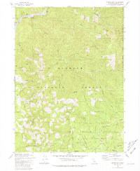
1980 Map of Ukonom Mountain
USGS Topo · Published 1981About this map
The Klamath River flows through the northern reaches of this Siskiyou County landscape, carving a deep valley through the Klamath National Forest. In the southern portion of the sheet, the Marble Mountain Wilderness protects a high-altitude terrain defined by expansive grassy openings like Long Meadow, Big Meadow, and Hells Meadows. These meadows likely served as critical landmarks for early forest travelers and packers moving through the high country.
Find a feature on this map
37 named features on this map. Tap any name to fly to it.
Don’t see what you’re looking for? This feature index may not catch every label — zoom into the map to look around manually.
Map Details
Editions of this 1980 Ukonom Mountain Map
This is the sole edition of this map. No revisions or reprints were ever made.
Other maps of this area

1914 · Seiad
USGS Topo · 1:125,000

1922 · Preston Peak
USGS Topo · 1:125,000

1922 · Seiad
USGS Topo · 1:125,000

1925 · Hoopa
USGS Topo · 1:125,000

1948 · Weed
USGS Topo · 1:250,000

1950 · Weed
USGS Topo · 1:250,000

1952 · Orleans
USGS Topo · 1:62,500

1955 · Dillon Mtn
USGS Topo · 1:62,500

1955 · Ukonom Lake
USGS Topo · 1:62,500

1955 · Forks of Salmon
USGS Topo · 1:62,500