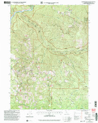
2001 Map of Ukonom Mountain
USGS Topo · Published 2004About this map
Klamath Wild and Scenic River carves through the northwestern corner of this Siskiyou County landscape, a region defined by high peaks and remote meadows at the start of the 21st century. The map centers on the high elevation of Ukonom Mtn, where a Lookout once stood to monitor the surrounding Klamath National Forest. The southeastern portion of the quadrangle transitions into the protected terrain of the Marble Mountain Wilderness, featuring a series of isolated clearings such as Stanshaw Meadows, Big Meadow, and Halfmoon Meadow. Small outpost locations like Jawbone Camp and Jims Camp suggest a landscape primarily utilized for forest management and back-country recreation. Drainage systems like Ukonom Creek and Haypress Creek feed into the river system, illustrating the steep, well-watered topography that characterizes the Happy Camp Ranger District.
Find a feature on this map
29 named features on this map. Tap any name to fly to it.
Don’t see what you’re looking for? This feature index may not catch every label — zoom into the map to look around manually.
Map Details
Editions of this 2001 Ukonom Mountain Map
This is the sole edition of this map. No revisions or reprints were ever made.
Other maps of this area

1914 · Seiad
USGS Topo · 1:125,000

1922 · Preston Peak
USGS Topo · 1:125,000

1922 · Seiad
USGS Topo · 1:125,000

1925 · Hoopa
USGS Topo · 1:125,000

1948 · Weed
USGS Topo · 1:250,000

1950 · Weed
USGS Topo · 1:250,000

1952 · Orleans
USGS Topo · 1:62,500

1955 · Dillon Mtn
USGS Topo · 1:62,500

1955 · Ukonom Lake
USGS Topo · 1:62,500

1955 · Forks of Salmon
USGS Topo · 1:62,500