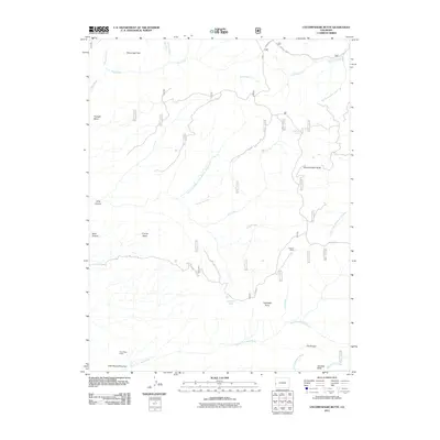
2011 Map of Uncompahgre Butte
USGS Topo · Published 2011About this map
Uncompahgre Butte stands as the central landmark of this high-plateau landscape in Mesa County, where the terrain is defined by deep incisions like Long Canyon and Deep Canyon. The 2011 survey reveals a complex network of forest and resource roads, including Divide Rd and Brushy Ridge, which navigate the mesas and basins. Water sources are vital features here, with California Spring and Campbell Lake serving the high ground, while numerous creeks like Blue Creek and the Beaver Dam Branch North Fork Mesa Creek drain the slopes. The presence of Colcord Camp and the Truck Stop Placer suggests the ongoing importance of seasonal activity and land use within these remote stretches. Geologic features such as Triangle Mesa and The Tongue illustrate the dramatic erosion patterns typical of this part of Colorado, providing a detailed view of the land before further modern developments altered the access routes or drainage patterns.
Find a feature on this map
53 named features on this map. Tap any name to fly to it.
Don’t see what you’re looking for? This feature index may not catch every label — zoom into the map to look around manually.
Map Details
Editions of this 2011 Uncompahgre Butte Map
This is the sole edition of this map. No revisions or reprints were ever made.
Other maps of this area

1916 · Paradox Valley
USGS Topo · 1:125,000

1922 · Paradox Valley
USGS Topo · 1:125,000

1949 · Atkinson Creek
USGS Topo · 1:24,000

1949 · Red Canyon
USGS Topo · 1:24,000

1949 · Calamity Mesa
USGS Topo · 1:24,000

1950 · Calamity Mesa
USGS Topo · 1:24,000

1950 · Pine Mountain
USGS Topo · 1:24,000

1950 · Atkinson Creek
USGS Topo · 1:24,000
1950 · Red Canyon
USGS Topo · 1:24,000

1956 · Moab
USGS Topo · 1:250,000