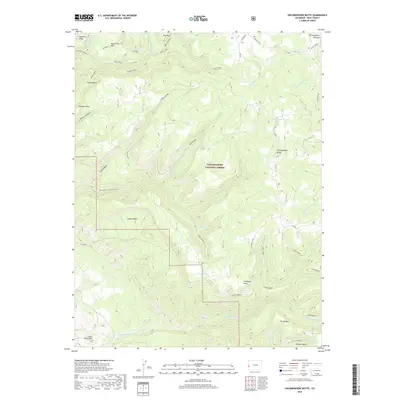
2019 Map of Uncompahgre Butte
USGS Topo · Published 2019About this map
Uncompahgre National Forest encompasses this high-elevation landscape on the Uncompahgre Plateau, where the terrain is defined by deep canyons and prominent mesas. The drainage network is complex, with Blue Creek and its tributary Mailbox Br Blue Cr carving through the northern reaches, while S Fork Mesa Cr and Little Johnson Cr dominate the southern aspect. High points like Uncompahgre Butte and Leonards Ridge provide significant landmarks within this managed wilderness. Localized features such as California Spring and Campbell Lake offer critical water sources in an otherwise arid environment characterized by features like Triangle Mesa and the Coyote Basin. The presence of the Mailbox Road and Smith Access suggests the continuing importance of these routes for forest management and local access across the township boundaries of t50n r17w and t50n r16w.
Find a feature on this map
46 named features on this map. Tap any name to fly to it.
Don’t see what you’re looking for? This feature index may not catch every label — zoom into the map to look around manually.
Map Details
Editions of this 2019 Uncompahgre Butte Map
This is the sole edition of this map. No revisions or reprints were ever made.
Other maps of this area

1916 · Paradox Valley
USGS Topo · 1:125,000

1922 · Paradox Valley
USGS Topo · 1:125,000

1949 · Atkinson Creek
USGS Topo · 1:24,000

1949 · Red Canyon
USGS Topo · 1:24,000

1949 · Calamity Mesa
USGS Topo · 1:24,000

1950 · Calamity Mesa
USGS Topo · 1:24,000

1950 · Pine Mountain
USGS Topo · 1:24,000

1950 · Atkinson Creek
USGS Topo · 1:24,000
1950 · Red Canyon
USGS Topo · 1:24,000

1956 · Moab
USGS Topo · 1:250,000