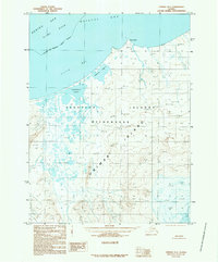
1989 Map of Unimak D-1
USGS Topo · Published 1989About this map
Unimak Island and the expansive Aleutian Islands Wilderness dominate this late-twentieth-century topographical survey. The landscape is characterized by its complex coastal hydrology, where the Bering Sea meets the northern shores of the archipelago at Cape Lapin. Further inland, the map details significant brackish water systems including Christianson Lagoon and Peterson Lagoon, which are separated from the open waters of Urilia Bay by narrow coastal strips. This environment, captured in the 1980s, reflects a territory largely untouched by industrial infrastructure, emphasizing natural features like Twin Peak and the submerged Slime Bank in Bristol Bay. The lack of roads or established settlements on the sheet underscores the remote nature of the Aleutians East Borough during this period.
Find a feature on this map
13 named features on this map. Tap any name to fly to it.
Don’t see what you’re looking for? This feature index may not catch every label — zoom into the map to look around manually.
Map Details
Editions of this 1989 Unimak D-1 Map
This is the sole edition of this map. No revisions or reprints were ever made.
Other maps of this area

1943 · Fort Randall
USGS Topo · 1:250,000

1949 · False Pass
USGS Topo · 1:250,000

1949 · Fort Randall
USGS Topo · 1:250,000

1950 · False Pass
USGS Topo · 1:250,000

1950 · Fort Randall
USGS Topo · 1:250,000

1951 · Unimak
USGS Topo · 1:250,000

1958 · Unimak
USGS Topo · 1:250,000

1989 · Unimak C-1
USGS Topo · 1:63,360
1989 · Unimak D-2
USGS Topo · 1:63,360
1989 · False Pass C-6
USGS Topo · 1:63,360