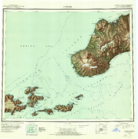
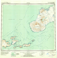
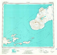
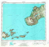
1951 Map of Unimak
USGS Topo · Published 1952About this map
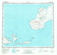
The volcanic peaks of the Tugamak Range and the massive Fisher Caldera dominate this Aleutian landscape, where high-altitude ice meets the rough waters of the Bering Sea. Published shortly after World War II, the sheet illustrates the critical maritime infrastructure and geological features of the island chain, notably the Cape Sarichef Lighthouse and the strategic outpost at Scotch Cap. Most of the land falls within the Aleutian Islands National Wildlife Refuge, preserving a wilderness defined by active geothermal landmarks like Pogromni Volcano and Westdahl Peak. To the southwest, the survey details the complex coastlines and smaller isles of the Krenitzin Islands, including the deep-water access of Akutan Harbor. This era of mapping relied on 1942 trimetrogon photography, providing a clear record of the lagoons, such as Peterson Lagoon, and the remote cabins that served as the few human structures in this maritime environment.
Find a feature on this map
95 named features on this map. Tap any name to fly to it.
Don’t see what you’re looking for? This feature index may not catch every label — zoom into the map to look around manually.
Map Details
Editions of this 1951 Unimak Map
7 editions found
Historical Maps of Akutan Through Time
384 maps found

1944 Cold Bay Sheet No. 1 of 25
Aleutians East Borough, AK

1944 Cold Bay Sheet No. 20 of 25
Aleutians East Borough, AK

1944 Cold Bay Sheet No. 2 of 25
Aleutians East Borough, AK

1949 Fort Randall
Aleutians East Borough, AK

1950 Fort Randall
Aleutians East Borough, AK

1951 Unimak
Aleutians East Borough, AK

1953 Port Moller
Aleutians East Borough, AK

1955 Beechey Point B-5
Aleutians East Borough, AK

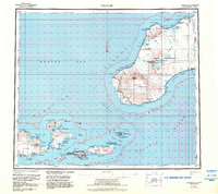
1958 Unimak
Aleutians East Borough, AK

1958 Unimak B-2 NE
Aleutians East Borough, AK

1963 Chignik A-6
Aleutians East Borough, AK

1963 Chignik A-7
Aleutians East Borough, AK

1963 Chignik A-8
Aleutians East Borough, AK

1963 Chignik B-7
Aleutians East Borough, AK

1963 Chignik C-5
Aleutians East Borough, AK

1963 Chignik C-6
Aleutians East Borough, AK

1963 Chignik D-4
Aleutians East Borough, AK

1963 Cold Bay B-3
Aleutians East Borough, AK

1963 Cold Bay B-4
Aleutians East Borough, AK

1963 Cold Bay C-1
Aleutians East Borough, AK

1963 Cold Bay C-2
Aleutians East Borough, AK

1963 Cold Bay D-1
Aleutians East Borough, AK

1963 False Pass C-1
Aleutians East Borough, AK

1963 False Pass C-2
Aleutians East Borough, AK

1963 False Pass D-0
Aleutians East Borough, AK

1963 False Pass D-1
Aleutians East Borough, AK

1963 False Pass D-2
Aleutians East Borough, AK

1963 False Pass D-3
Aleutians East Borough, AK

1963 Port Moller A-1
Aleutians East Borough, AK

1963 Port Moller A-2
Aleutians East Borough, AK

1963 Port Moller A-3
Aleutians East Borough, AK

1963 Port Moller A-4
Aleutians East Borough, AK

1963 Port Moller A-5
Aleutians East Borough, AK

1963 Port Moller A-6
Aleutians East Borough, AK

1963 Port Moller B-1
Aleutians East Borough, AK

1963 Port Moller B-2
Aleutians East Borough, AK

1963 Port Moller C-1
Aleutians East Borough, AK

1963 Port Moller C-2
Aleutians East Borough, AK

1963 Port Moller C-5
Aleutians East Borough, AK

1963 Port Moller C-6
Aleutians East Borough, AK

1963 Port Moller D-1
Aleutians East Borough, AK

1963 Port Moller D-2
Aleutians East Borough, AK

1963 Port Moller D-3
Aleutians East Borough, AK

1963 Port Moller D-4
Aleutians East Borough, AK

1963 Port Moller D-5
Aleutians East Borough, AK

1963 Port Moller D-6
Aleutians East Borough, AK

1963 Simeonof Island
Aleutians East Borough, AK

1963 Simeonof Island D-1
Aleutians East Borough, AK

1963 Simeonof Island D-2
Aleutians East Borough, AK

1963 Simeonof Island D-3
Aleutians East Borough, AK

1963 Simeonof Island D-4
Aleutians East Borough, AK

1963 Stepovak Bay A-5
Aleutians East Borough, AK

1963 Stepovak Bay A-6
Aleutians East Borough, AK

1963 Stepovak Bay B-6
Aleutians East Borough, AK

1963 Stepovak Bay C-5 and C-6
Aleutians East Borough, AK

1963 Stepovak Bay D-6
Aleutians East Borough, AK

1967 Simeonof Island
Aleutians East Borough, AK

1983 Cold Bay A-1
Aleutians East Borough, AK

1983 Cold Bay B-1
Aleutians East Borough, AK

1983 Port Moller B-3
Aleutians East Borough, AK

1983 Port Moller B-4
Aleutians East Borough, AK

1983 Port Moller B-5
Aleutians East Borough, AK

1983 Port Moller B-6
Aleutians East Borough, AK

1983 Port Moller C-3
Aleutians East Borough, AK

1983 Port Moller C-4
Aleutians East Borough, AK

1988 Port Moller
Aleutians East Borough, AK

1989 Cold Bay A-6
Aleutians East Borough, AK

1989 False Pass B-2
Aleutians East Borough, AK

1989 False Pass B-3
Aleutians East Borough, AK

1989 False Pass C-4
Aleutians East Borough, AK

1989 False Pass C-5
Aleutians East Borough, AK

1989 False Pass C-6
Aleutians East Borough, AK

1989 False Pass D-6
Aleutians East Borough, AK

1989 Unalaska D-1
Aleutians East Borough, AK

1989 Unimak A-3
Aleutians East Borough, AK

1989 Unimak A-4
Aleutians East Borough, AK

1989 Unimak A-5
Aleutians East Borough, AK

1989 Unimak A-6
Aleutians East Borough, AK

1989 Unimak B-2
Aleutians East Borough, AK

1989 Unimak B-3
Aleutians East Borough, AK

1989 Unimak B-5
Aleutians East Borough, AK

1989 Unimak B-6
Aleutians East Borough, AK

1989 Unimak C-1
Aleutians East Borough, AK

1989 Unimak C-2
Aleutians East Borough, AK

1989 Unimak C-3
Aleutians East Borough, AK

1989 Unimak D-1
Aleutians East Borough, AK

1989 Unimak D-2
Aleutians East Borough, AK

1995 Cold Bay A-2
Aleutians East Borough, AK

1995 Cold Bay A-3
Aleutians East Borough, AK

1995 Cold Bay A-4
Aleutians East Borough, AK

1995 Cold Bay A-5
Aleutians East Borough, AK

1995 Cold Bay B-2
Aleutians East Borough, AK

1995 False Pass D-4
Aleutians East Borough, AK

1995 False Pass D-5
Aleutians East Borough, AK

2017 Sitka A-1 NW
Aleutians East Borough, AK

2020 Chignik A-6 NW
Aleutians East Borough, AK

2020 Chignik A-6 SW
Aleutians East Borough, AK

2020 Chignik A-7 NE
Aleutians East Borough, AK

2020 Chignik A-7 NW
Aleutians East Borough, AK

2020 Chignik A-7 SE
Aleutians East Borough, AK

2020 Chignik A-7 SW
Aleutians East Borough, AK

2020 Chignik A-8 NE
Aleutians East Borough, AK

2020 Chignik A-8 SE
Aleutians East Borough, AK

2020 Chignik B-6 NW
Aleutians East Borough, AK

2020 Chignik B-6 SW
Aleutians East Borough, AK

2020 Chignik B-7 NE
Aleutians East Borough, AK

2020 Chignik B-7 NW
Aleutians East Borough, AK

2020 Chignik B-7 OE W SW
Aleutians East Borough, AK

2020 Chignik B-7 SE
Aleutians East Borough, AK

2020 Chignik B-7 SW
Aleutians East Borough, AK

2020 Chignik C-4 NW
Aleutians East Borough, AK

2020 Chignik C-5 NE
Aleutians East Borough, AK

2020 Chignik C-5 NW
Aleutians East Borough, AK

2020 Chignik C-6 SE
Aleutians East Borough, AK

2020 Chignik C-6 SW
Aleutians East Borough, AK

2020 Chignik D-4 SE
Aleutians East Borough, AK

2020 Chignik D-4 SW
Aleutians East Borough, AK

2020 Cold Bay A-1 NE
Aleutians East Borough, AK

2020 Cold Bay A-1 NW
Aleutians East Borough, AK

2020 Cold Bay A-1 SE
Aleutians East Borough, AK

2020 Cold Bay A-1 SW
Aleutians East Borough, AK

2020 Cold Bay A-2 NE
Aleutians East Borough, AK

2020 Cold Bay A-2 NW
Aleutians East Borough, AK

2020 Cold Bay A-2 SE
Aleutians East Borough, AK

2020 Cold Bay A-2 SW
Aleutians East Borough, AK

2020 Cold Bay A-3 NE
Aleutians East Borough, AK

2020 Cold Bay A-3 NW
Aleutians East Borough, AK

2020 Cold Bay A-3 SE
Aleutians East Borough, AK

2020 Cold Bay A-3 SW
Aleutians East Borough, AK

2020 Cold Bay A-4 NE
Aleutians East Borough, AK

2020 Cold Bay A-4 NW
Aleutians East Borough, AK

2020 Cold Bay A-4 SE
Aleutians East Borough, AK

2020 Cold Bay A-4 SW
Aleutians East Borough, AK

2020 Cold Bay A-5 SE
Aleutians East Borough, AK

2020 Cold Bay A-5 SW
Aleutians East Borough, AK

2020 Cold Bay A-6 SE
Aleutians East Borough, AK

2020 Cold Bay A-6 SW
Aleutians East Borough, AK

2020 Cold Bay B-1 NE
Aleutians East Borough, AK

2020 Cold Bay B-1 NW
Aleutians East Borough, AK

2020 Cold Bay B-1 SE
Aleutians East Borough, AK

2020 Cold Bay B-1 SW
Aleutians East Borough, AK

2020 Cold Bay B-2 NE
Aleutians East Borough, AK

2020 Cold Bay B-2 NW
Aleutians East Borough, AK

2020 Cold Bay B-2 SE
Aleutians East Borough, AK

2020 Cold Bay B-2 SW
Aleutians East Borough, AK

2020 Cold Bay B-3 NE
Aleutians East Borough, AK

2020 Cold Bay B-3 SE
Aleutians East Borough, AK

2020 Cold Bay B-3 SW
Aleutians East Borough, AK

2020 Cold Bay B-4 NE
Aleutians East Borough, AK

2020 Cold Bay B-4 NW
Aleutians East Borough, AK

2020 Cold Bay C-1 NE
Aleutians East Borough, AK

2020 Cold Bay C-1 NW
Aleutians East Borough, AK

2020 Cold Bay C-1 SE
Aleutians East Borough, AK

2020 Cold Bay C-1 SW
Aleutians East Borough, AK

2020 Cold Bay C-2 SE
Aleutians East Borough, AK

2020 Cold Bay D-1 SE
Aleutians East Borough, AK

2020 False Pass B-2 NE
Aleutians East Borough, AK

2020 False Pass B-2 NW
Aleutians East Borough, AK

2020 False Pass B-2 SE
Aleutians East Borough, AK

2020 False Pass B-2 SW
Aleutians East Borough, AK

2020 False Pass B-3 NE
Aleutians East Borough, AK

2020 False Pass B-3 NW
Aleutians East Borough, AK

2020 False Pass B-3 SE
Aleutians East Borough, AK

2020 False Pass B-3 SW
Aleutians East Borough, AK

2020 False Pass B-4 SE
Aleutians East Borough, AK

2020 False Pass C-1 NE
Aleutians East Borough, AK

2020 False Pass C-1 NW
Aleutians East Borough, AK

2020 False Pass C-1 SE
Aleutians East Borough, AK

2020 False Pass C-1 SW
Aleutians East Borough, AK

2020 False Pass C-2 NE
Aleutians East Borough, AK

2020 False Pass C-2 SE
Aleutians East Borough, AK

2020 False Pass C-3 NW
Aleutians East Borough, AK

2020 False Pass C-3 SE
Aleutians East Borough, AK

2020 False Pass C-3 SW
Aleutians East Borough, AK

2020 False Pass C-4 NE
Aleutians East Borough, AK

2020 False Pass C-4 NW
Aleutians East Borough, AK

2020 False Pass C-5 NE
Aleutians East Borough, AK

2020 False Pass C-5 NW
Aleutians East Borough, AK

2020 False Pass C-5 SE
Aleutians East Borough, AK

2020 False Pass C-5 SW
Aleutians East Borough, AK

2020 False Pass C-6 NE
Aleutians East Borough, AK

2020 False Pass C-6 NW
Aleutians East Borough, AK

2020 False Pass D-0 NE
Aleutians East Borough, AK

2020 False Pass D-0 NW
Aleutians East Borough, AK

2020 False Pass D-0 OE E NW
Aleutians East Borough, AK

2020 False Pass D-0 OE E SW
Aleutians East Borough, AK

2020 False Pass D-0 SE
Aleutians East Borough, AK

2020 False Pass D-0 SW
Aleutians East Borough, AK

2020 False Pass D-1 NE
Aleutians East Borough, AK

2020 False Pass D-1 NW
Aleutians East Borough, AK

2020 False Pass D-1 SE
Aleutians East Borough, AK

2020 False Pass D-1 SW
Aleutians East Borough, AK

2020 False Pass D-2 NE
Aleutians East Borough, AK

2020 False Pass D-2 NW
Aleutians East Borough, AK

2020 False Pass D-2 SE
Aleutians East Borough, AK

2020 False Pass D-2 SW
Aleutians East Borough, AK

2020 False Pass D-3 NE
Aleutians East Borough, AK

2020 False Pass D-3 NW
Aleutians East Borough, AK

2020 False Pass D-3 SE
Aleutians East Borough, AK

2020 False Pass D-4 NE
Aleutians East Borough, AK

2020 False Pass D-4 NW
Aleutians East Borough, AK

2020 False Pass D-4 SE
Aleutians East Borough, AK

2020 False Pass D-4 SW
Aleutians East Borough, AK

2020 False Pass D-5 NE
Aleutians East Borough, AK

2020 False Pass D-5 NW
Aleutians East Borough, AK

2020 False Pass D-5 SE
Aleutians East Borough, AK

2020 False Pass D-5 SW
Aleutians East Borough, AK

2020 False Pass D-6 NE
Aleutians East Borough, AK

2020 False Pass D-6 NW
Aleutians East Borough, AK

2020 False Pass D-6 SE
Aleutians East Borough, AK

2020 False Pass D-6 SW
Aleutians East Borough, AK

2020 Port Moller A-1 NE
Aleutians East Borough, AK

2020 Port Moller A-1 NW
Aleutians East Borough, AK

2020 Port Moller A-1 SE
Aleutians East Borough, AK

2020 Port Moller A-1 SW
Aleutians East Borough, AK

2020 Port Moller A-2 NE
Aleutians East Borough, AK

2020 Port Moller A-2 NW
Aleutians East Borough, AK

2020 Port Moller A-2 SW
Aleutians East Borough, AK

2020 Port Moller A-3 NE
Aleutians East Borough, AK

2020 Port Moller A-3 NW
Aleutians East Borough, AK

2020 Port Moller A-3 SE
Aleutians East Borough, AK

2020 Port Moller A-4 NE
Aleutians East Borough, AK

2020 Port Moller A-4 NW
Aleutians East Borough, AK

2020 Port Moller A-5 NE
Aleutians East Borough, AK

2020 Port Moller A-5 NW
Aleutians East Borough, AK

2020 Port Moller A-5 SE
Aleutians East Borough, AK

2020 Port Moller A-5 SW
Aleutians East Borough, AK

2020 Port Moller A-6 NE
Aleutians East Borough, AK

2020 Port Moller A-6 NW
Aleutians East Borough, AK

2020 Port Moller A-6 SE
Aleutians East Borough, AK

2020 Port Moller A-6 SW
Aleutians East Borough, AK

2020 Port Moller B-1 NE
Aleutians East Borough, AK

2020 Port Moller B-1 NW
Aleutians East Borough, AK

2020 Port Moller B-1 SE
Aleutians East Borough, AK

2020 Port Moller B-1 SW
Aleutians East Borough, AK

2020 Port Moller B-2 NE
Aleutians East Borough, AK

2020 Port Moller B-2 NW
Aleutians East Borough, AK

2020 Port Moller B-2 SE
Aleutians East Borough, AK

2020 Port Moller B-2 SW
Aleutians East Borough, AK

2020 Port Moller B-3 NE
Aleutians East Borough, AK

2020 Port Moller B-3 NW
Aleutians East Borough, AK

2020 Port Moller B-3 SE
Aleutians East Borough, AK

2020 Port Moller B-3 SW
Aleutians East Borough, AK

2020 Port Moller B-4 NE
Aleutians East Borough, AK

2020 Port Moller B-4 NW
Aleutians East Borough, AK

2020 Port Moller B-4 SE
Aleutians East Borough, AK

2020 Port Moller B-4 SW
Aleutians East Borough, AK

2020 Port Moller B-5 NE
Aleutians East Borough, AK

2020 Port Moller B-5 NW
Aleutians East Borough, AK

2020 Port Moller B-5 SE
Aleutians East Borough, AK

2020 Port Moller B-5 SW
Aleutians East Borough, AK

2020 Port Moller B-6 NE
Aleutians East Borough, AK

2020 Port Moller B-6 NW
Aleutians East Borough, AK

2020 Port Moller B-6 SE
Aleutians East Borough, AK

2020 Port Moller B-6 SW
Aleutians East Borough, AK

2020 Port Moller C-1 NE
Aleutians East Borough, AK

2020 Port Moller C-1 NW
Aleutians East Borough, AK

2020 Port Moller C-1 SE
Aleutians East Borough, AK

2020 Port Moller C-2 NE
Aleutians East Borough, AK

2020 Port Moller C-2 NW
Aleutians East Borough, AK

2020 Port Moller C-2 SE
Aleutians East Borough, AK

2020 Port Moller C-2 SW
Aleutians East Borough, AK

2020 Port Moller C-3 NE
Aleutians East Borough, AK

2020 Port Moller C-3 NW
Aleutians East Borough, AK

2020 Port Moller C-3 SE
Aleutians East Borough, AK

2020 Port Moller C-3 SW
Aleutians East Borough, AK

2020 Port Moller C-4 NE
Aleutians East Borough, AK

2020 Port Moller C-4 NW
Aleutians East Borough, AK

2020 Port Moller C-4 SE
Aleutians East Borough, AK

2020 Port Moller C-4 SW
Aleutians East Borough, AK

2020 Port Moller C-5 NE
Aleutians East Borough, AK

2020 Port Moller C-5 NW
Aleutians East Borough, AK

2020 Port Moller C-5 SE
Aleutians East Borough, AK

2020 Port Moller C-5 SW
Aleutians East Borough, AK

2020 Port Moller C-6 NE
Aleutians East Borough, AK

2020 Port Moller C-6 NW
Aleutians East Borough, AK

2020 Port Moller C-6 SE
Aleutians East Borough, AK

2020 Port Moller C-6 SW
Aleutians East Borough, AK

2020 Port Moller D-1 NE
Aleutians East Borough, AK

2020 Port Moller D-1 NW
Aleutians East Borough, AK

2020 Port Moller D-1 SE
Aleutians East Borough, AK

2020 Port Moller D-1 SW
Aleutians East Borough, AK

2020 Port Moller D-2 NE
Aleutians East Borough, AK

2020 Port Moller D-2 NW
Aleutians East Borough, AK

2020 Port Moller D-2 SE
Aleutians East Borough, AK

2020 Port Moller D-2 SW
Aleutians East Borough, AK

2020 Port Moller D-3 NE
Aleutians East Borough, AK

2020 Port Moller D-3 NW
Aleutians East Borough, AK

2020 Port Moller D-3 OE N SE
Aleutians East Borough, AK

2020 Port Moller D-3 OE N SW
Aleutians East Borough, AK

2020 Port Moller D-3 SE
Aleutians East Borough, AK

2020 Port Moller D-3 SW
Aleutians East Borough, AK

2020 Port Moller D-4 NE
Aleutians East Borough, AK

2020 Port Moller D-4 NW
Aleutians East Borough, AK

2020 Port Moller D-4 OE N SE
Aleutians East Borough, AK

2020 Port Moller D-4 OE N SW
Aleutians East Borough, AK

2020 Port Moller D-4 SE
Aleutians East Borough, AK

2020 Port Moller D-4 SW
Aleutians East Borough, AK

2020 Port Moller D-5 NE
Aleutians East Borough, AK

2020 Port Moller D-5 NW
Aleutians East Borough, AK

2020 Port Moller D-5 SE
Aleutians East Borough, AK

2020 Port Moller D-5 SW
Aleutians East Borough, AK

2020 Port Moller D-6 NE
Aleutians East Borough, AK

2020 Port Moller D-6 NW
Aleutians East Borough, AK

2020 Port Moller D-6 SE
Aleutians East Borough, AK

2020 Port Moller D-6 SW
Aleutians East Borough, AK

2020 Simeonof Island D-1 NW
Aleutians East Borough, AK

2020 Simeonof Island D-1 SW
Aleutians East Borough, AK

2020 Simeonof Island D-2 NE
Aleutians East Borough, AK

2020 Simeonof Island D-2 SW
Aleutians East Borough, AK

2020 Simeonof Island D-3 NW
Aleutians East Borough, AK

2020 Simeonof Island D-3 SE
Aleutians East Borough, AK

2020 Simeonof Island D-4 NE
Aleutians East Borough, AK

2020 Simeonof Island D-4 NW
Aleutians East Borough, AK

2020 Simeonof Island D-4 SW
Aleutians East Borough, AK

2020 Stepovak Bay A-5 NE
Aleutians East Borough, AK

2020 Stepovak Bay A-5 NW
Aleutians East Borough, AK

2020 Stepovak Bay A-5 OE E SW
Aleutians East Borough, AK

2020 Stepovak Bay A-5 OE N SW
Aleutians East Borough, AK

2020 Stepovak Bay A-5 SE
Aleutians East Borough, AK

2020 Stepovak Bay A-5 SW
Aleutians East Borough, AK

2020 Stepovak Bay A-6 NE
Aleutians East Borough, AK

2020 Stepovak Bay A-6 NW
Aleutians East Borough, AK

2020 Stepovak Bay A-6 SE
Aleutians East Borough, AK

2020 Stepovak Bay A-6 SW
Aleutians East Borough, AK

2020 Stepovak Bay B-6 SW
Aleutians East Borough, AK

2020 Stepovak Bay C-5 NW
Aleutians East Borough, AK

2020 Stepovak Bay C-5 SW
Aleutians East Borough, AK

2020 Stepovak Bay C-6 NE
Aleutians East Borough, AK

2020 Stepovak Bay C-6 SE
Aleutians East Borough, AK

2020 Stepovak Bay D-5 SW
Aleutians East Borough, AK

2020 Stepovak Bay D-6 NW
Aleutians East Borough, AK

2020 Stepovak Bay D-6 SE
Aleutians East Borough, AK

2020 Stepovak Bay D-6 SW
Aleutians East Borough, AK

2020 Unalaska C-1 NE
Aleutians East Borough, AK

2020 Unalaska D-1 NE
Aleutians East Borough, AK

2020 Unalaska D-1 SE
Aleutians East Borough, AK

2020 Unalaska D-1 SW
Aleutians East Borough, AK

2020 Unimak A-3 NE
Aleutians East Borough, AK

2020 Unimak A-3 SW
Aleutians East Borough, AK

2020 Unimak A-4 NE
Aleutians East Borough, AK

2020 Unimak A-4 NW
Aleutians East Borough, AK

2020 Unimak A-4 SE
Aleutians East Borough, AK

2020 Unimak A-4 SW
Aleutians East Borough, AK

2020 Unimak A-5 NE
Aleutians East Borough, AK

2020 Unimak A-5 NW
Aleutians East Borough, AK

2020 Unimak A-5 SE
Aleutians East Borough, AK

2020 Unimak A-5 SW
Aleutians East Borough, AK

2020 Unimak A-6 NE
Aleutians East Borough, AK

2020 Unimak A-6 NW
Aleutians East Borough, AK

2020 Unimak A-6 SE
Aleutians East Borough, AK

2020 Unimak A-6 SW
Aleutians East Borough, AK

2020 Unimak B-2 NW
Aleutians East Borough, AK

2020 Unimak B-2 OE E NW
Aleutians East Borough, AK

2020 Unimak B-5 SE
Aleutians East Borough, AK

2020 Unimak B-5 SW
Aleutians East Borough, AK

2020 Unimak B-6 SE
Aleutians East Borough, AK

2021 Sitka A-1 NW
Aleutians East Borough, AK

2021 Unimak A-3 NW
Aleutians East Borough, AK

2021 Unimak B-2 NE
Aleutians East Borough, AK

2021 Unimak B-3 NE
Aleutians East Borough, AK

2021 Unimak B-3 NW
Aleutians East Borough, AK

2021 Unimak C-1 NE
Aleutians East Borough, AK

2021 Unimak C-1 NW
Aleutians East Borough, AK

2021 Unimak C-1 SE
Aleutians East Borough, AK

2021 Unimak C-1 SW
Aleutians East Borough, AK

2021 Unimak C-2 NE
Aleutians East Borough, AK

2021 Unimak C-2 NW
Aleutians East Borough, AK

2021 Unimak C-2 SE
Aleutians East Borough, AK

2021 Unimak C-2 SW
Aleutians East Borough, AK

2021 Unimak C-3 NE
Aleutians East Borough, AK

2021 Unimak C-3 NW
Aleutians East Borough, AK

2021 Unimak C-3 SE
Aleutians East Borough, AK

2021 Unimak C-3 SW
Aleutians East Borough, AK

2021 Unimak D-1 NE
Aleutians East Borough, AK

2021 Unimak D-1 NW
Aleutians East Borough, AK

2021 Unimak D-1 SE
Aleutians East Borough, AK

2021 Unimak D-1 SW
Aleutians East Borough, AK

2021 Unimak D-2 NE
Aleutians East Borough, AK

2021 Unimak D-2 NW
Aleutians East Borough, AK

2021 Unimak D-2 SE
Aleutians East Borough, AK

2021 Unimak D-2 SW
Aleutians East Borough, AK

2023 Port Moller A-2 NW
Aleutians East Borough, AK

2024 Sitka A-1 NW
Aleutians East Borough, AK