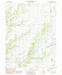
1984 Map of Union Center
USGS Topo · Published 1985About this map
Union Center and the surrounding farmland of Cumberland County are defined by a network of drainage creeks in this 1980s-era study. The landscape is a patchwork of agricultural fields and small rural settlements like Maple Point and Vevay Park, where the local economy transitions from traditional farming to natural resource extraction. Active Oil Field operations and a Gravel Pit appear alongside the waterways of Hurricane Creek and Crooked Creek. The eastern edge of the quadrangle shows the suburban fringe and transportation infrastructure of a larger neighboring community, including the Muni Airport and the rail line of the Casey Corp. This map captures the region's character just as modern land-use patterns were solidifying over the historical rural townships of Union and Greenup.
Find a feature on this map
21 named features on this map. Tap any name to fly to it.
Don’t see what you’re looking for? This feature index may not catch every label — zoom into the map to look around manually.
Map Details
Editions of this 1984 Union Center Map
This is the sole edition of this map. No revisions or reprints were ever made.
Other maps of this area

1933 · Toledo
USGS Topo · 1:62,500

1936 · Casey
USGS Topo · 1:48,000

1938 · Toledo
USGS Topo · 1:62,500

1940 · Greenup
USGS Topo · 1:62,500

1942 · Casey
USGS Topo · 1:62,500

1943 · Greenup
USGS Topo · 1:62,500

1943 · Casey
USGS Topo · 1:62,500

1953 · Indianapolis
USGS Topo · 1:250,000

1956 · Indianapolis
USGS Topo · 1:250,000

1956 · Annapolis
USGS Topo · 1:62,500