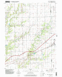
1998 Map of Union Center
USGS Topo · Published 2003About this map
Union Center and Maple Point anchor this rural landscape in Cumberland County, where the transition from agriculture to energy extraction is evident. The landscape is heavily marked by industrial activity, specifically across Wolf Field, which is dotted with numerous oil wells and drill holes. This infrastructure suggests a long-standing reliance on subterranean resources, a common theme in the Illinois Basin during this period. Local transportation is defined by a mix of modern transit and historical remnants, including the Old RR Grade and several utility landmarks like the Ruffner Comm Tower and the Gaging Station. Drainage is provided by a network of waterways including Hurricane Creek, Ranger Creek, and Birch Creek, which eventually feed into the larger Crooked Creek to the south. These features reveal a community organized around its natural drainage patterns and the technical requirements of the oil industry.
Find a feature on this map
32 named features on this map. Tap any name to fly to it.
Don’t see what you’re looking for? This feature index may not catch every label — zoom into the map to look around manually.
Map Details
Editions of this 1998 Union Center Map
This is the sole edition of this map. No revisions or reprints were ever made.
Other maps of this area

1933 · Toledo
USGS Topo · 1:62,500

1936 · Casey
USGS Topo · 1:48,000

1938 · Toledo
USGS Topo · 1:62,500

1940 · Greenup
USGS Topo · 1:62,500

1942 · Casey
USGS Topo · 1:62,500

1943 · Greenup
USGS Topo · 1:62,500

1943 · Casey
USGS Topo · 1:62,500

1953 · Indianapolis
USGS Topo · 1:250,000

1956 · Indianapolis
USGS Topo · 1:250,000

1956 · Annapolis
USGS Topo · 1:62,500