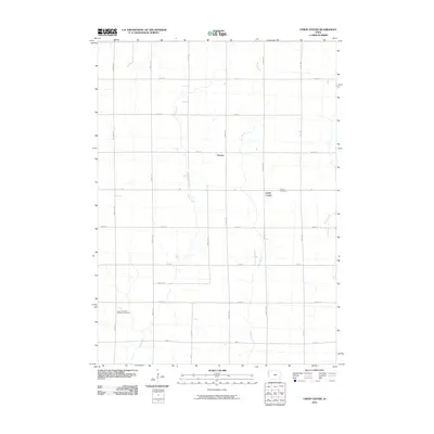
2010 Map of Union Center
USGS Topo · Published 2010About this map
Union Center and the surrounding farmland of Plymouth County are defined by a strict grid of county roads and the winding paths of several regional waterways. This agricultural landscape is drained by Mud Creek, which flows south through the center of the sheet, while the headwaters of Johns Creek and the multiple forks of Dry Branch carve subtle relief into the terrain. The map documents the persistent rural footprint of the area, anchored by the settlement at O'Leary and two significant burial grounds for local genealogy: Union Cemetery and Saint Josephs Catholic Cemetery. These locations, positioned along routes like Nature Ave and Pioneer Ave, represent the community's historical centers in an era where the landscape is almost entirely dedicated to large-scale production.
Find a feature on this map
23 named features on this map. Tap any name to fly to it.
Don’t see what you’re looking for? This feature index may not catch every label — zoom into the map to look around manually.
Map Details
Editions of this 2010 Union Center Map
This is the sole edition of this map. No revisions or reprints were ever made.
Other maps of this area

1954 · Fort Dodge
USGS Topo · 1:250,000

1955 · Sioux City
USGS Topo · 1:250,000

1957 · Fort Dodge
USGS Topo · 1:250,000

1958 · Sioux City
USGS Topo · 1:250,000

1958 · Fort Dodge
USGS Topo · 1:250,000

1959 · Sioux City
USGS Topo · 1:250,000

1962 · Le Mars
USGS Topo · 1:62,500

1962 · Union Center
USGS Topo · 1:62,500
1969 · Kingsley
USGS Topo · 1:24,000
1969 · Remsen
USGS Topo · 1:24,000