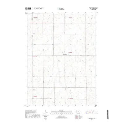
2018 Map of Union Center
USGS Topo · Published 2018About this map
Union Center and the neighboring community of O'Leary anchor this agricultural landscape in Plymouth County, which maintains a grid-like settlement pattern established during the era of frontier land surveys. The terrain is defined by the drainage systems of Mud Cr and Dry Br, which carve distinct valleys through the surrounding fields. Local history and genealogy are centered on the Union Cem and Saint Josephs Catholic Cem, which represent the spiritual and ancestral hubs of this rural township. A dense network of roads, including Co Rd C44 and north-south corridors like Nature Ave and Polk Ave, illustrates the persistence of the section-line road system that has facilitated Iowa farming for generations. Small waterways like Big Whiskey Cr and Johns Cr further define the local hydrology, providing natural landmarks within the highly structured township and range system.
Find a feature on this map
33 named features on this map. Tap any name to fly to it.
Don’t see what you’re looking for? This feature index may not catch every label — zoom into the map to look around manually.
Map Details
Editions of this 2018 Union Center Map
This is the sole edition of this map. No revisions or reprints were ever made.
Other maps of this area
1954 · Fort Dodge
USGS Topo · 1:250,000
1955 · Sioux City
USGS Topo · 1:250,000
1957 · Fort Dodge
USGS Topo · 1:250,000
1958 · Sioux City
USGS Topo · 1:250,000
1958 · Fort Dodge
USGS Topo · 1:250,000
1959 · Sioux City
USGS Topo · 1:250,000
1962 · Le Mars
USGS Topo · 1:62,500
1962 · Union Center
USGS Topo · 1:62,500
1969 · Kingsley
USGS Topo · 1:24,000
1969 · Remsen
USGS Topo · 1:24,000