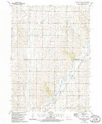
1985 Map of Union Center SE
USGS Topo · Published 1986About this map
The Little Sioux River and its tributary, the West Fork Little Sioux River, dominate this mid-1980s landscape at the border of Plymouth and Woodbury Counties. The terrain is defined by a dense network of drainage systems, including Mud Creek, Dry Branch, and West Mud Creek, which cut through the agricultural sections of Lincoln, Elkhorn, and Arlington. Evidence of local industry and infrastructure is visible through the presence of several Gravel Pit operations and a significant Pipeline corridor crossing the region. Recreational land use is preserved at Southeast Wildwood County Park in the northeast and Midway County Park further south, while a modern Levee system reflects local efforts to manage the river's influence on the surrounding township lands of Banner and Arlington.
Find a feature on this map
19 named features on this map. Tap any name to fly to it.
Don’t see what you’re looking for? This feature index may not catch every label — zoom into the map to look around manually.
Map Details
Editions of this 1985 Union Center SE Map
This is the sole edition of this map. No revisions or reprints were ever made.
Other maps of this area

1954 · Fort Dodge
USGS Topo · 1:250,000

1955 · Sioux City
USGS Topo · 1:250,000

1957 · Fort Dodge
USGS Topo · 1:250,000

1958 · Sioux City
USGS Topo · 1:250,000

1958 · Fort Dodge
USGS Topo · 1:250,000

1959 · Sioux City
USGS Topo · 1:250,000

1962 · Union Center
USGS Topo · 1:62,500

1964 · Lawton
USGS Topo · 1:24,000

1964 · Moville
USGS Topo · 1:24,000

1969 · Correctionville NW
USGS Topo · 1:24,000