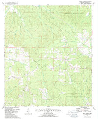
1988 Map of Union Church
USGS Topo · Published 1988About this map
Union Church and the surrounding woodlands of the Homochitto National Forest define this 1980s landscape in Jefferson County. The settlement patterns here follow the winding drainage of the Middle Fork Homochitto River and its numerous tributaries like Fifteenmile Creek and Hurricane Creek. This map offers significant genealogical value, documenting several rural congregations and burial grounds, including Hickory Block Ch, Mt Moriah Ch, and the Norton Cem. These sites, along with the small community of Perth, represent the established social fabric of this timber-rich region. The map also records mid-century infrastructure and industrial touches, from a network of Pipelines and Gas Wells to a prominent Radio Tower and Water Tank, illustrating how utility and resource extraction integrated into the forest landscape.
Find a feature on this map
35 named features on this map. Tap any name to fly to it.
Don’t see what you’re looking for? This feature index may not catch every label — zoom into the map to look around manually.
Map Details
Editions of this 1988 Union Church Map
This is the sole edition of this map. No revisions or reprints were ever made.
Other maps of this area

1953 · Natchez
USGS Topo · 1:250,000

1956 · Natchez
USGS Topo · 1:250,000

1959 · Natchez
USGS Topo · 1:250,000

1963 · Red Lick
USGS Topo · 1:24,000

1963 · Union Church
USGS Topo · 1:62,500

1963 · McBride
USGS Topo · 1:24,000

1963 · Barlow
USGS Topo · 1:24,000

1972 · McCall Creek
USGS Topo · 1:24,000

1972 · Caseyville
USGS Topo · 1:24,000

1984 · Brookhaven
USGS Topo · 1:100,000