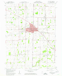
1960 Map of Union City
USGS Topo · Published 1961About this map
Union City straddles the Indiana Ohio State Line in this 1960 survey, serving as a significant railroad junction where the Pennsylvania RR, New York Central RR, and Baltimore and Ohio RR converge. The urban center is densely developed with civic landmarks like the City Hall, Post Office, and a Hospital, while the surrounding landscape is defined by agricultural drainage systems and small rural clusters.
Find a feature on this map
59 named features on this map. Tap any name to fly to it.
Don’t see what you’re looking for? This feature index may not catch every label — zoom into the map to look around manually.
Map Details
Editions of this 1960 Union City Map
4 editions found
Other maps of this area

1908 · St. Henry
USGS Topo · 1:62,500

1915 · Fort Recovery
USGS Topo · 1:48,000

1916 · Winchester
USGS Topo · 1:48,000

1918 · Winchester
USGS Topo · 1:62,500

1918 · Fort Recovery
USGS Topo · 1:62,500

1943 · Winchester
USGS Topo · 1:62,500

1953 · Muncie
USGS Topo · 1:250,000

1956 · Muncie
USGS Topo · 1:250,000

1960 · Union City
USGS Topo · 1:24,000
1960 · Spartanburg
USGS Topo · 1:24,000