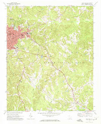
1971 Map of Union East
USGS Topo · Published 1974About this map
Union serves as the focal point of this 1971 survey, showing the city's eastern expansion and educational infrastructure including the Univ of South Carolina Regional Campus and Sims High Sch. The industrial character of the era is evident at Monarch, where a Settling Basin sits near the Southern railroad line. Moving southeast, the landscape transitions into the wooded stretches of the Sumter National Forest, drained by a network of waterways like Tinker Creek and Gregorys Creek. Local history is well-preserved through numerous rural landmarks, from the Sardis Ch and Beulah Ch to established burial grounds such as Forest Lawn Cem and Rosemont Cem. The map provides a detailed view of the small community of Santuc at the southern edge, illustrating the relationship between small Upstate settlements and the regional rail corridors that once defined South Carolina’s interior economy.
Find a feature on this map
41 named features on this map. Tap any name to fly to it.
Don’t see what you’re looking for? This feature index may not catch every label — zoom into the map to look around manually.
Map Details
Editions of this 1971 Union East Map
This is the sole edition of this map. No revisions or reprints were ever made.
Other maps of this area

1907 · Sharon
USGS Topo · 1:62,500

1941 · Spartanburg
USGS Topo · 1:250,000

1953 · Spartanburg
USGS Topo · 1:250,000

1960 · Spartanburg
USGS Topo · 1:250,000

1963 · Spartanburg
USGS Topo · 1:250,000

1964 · Spartanburg
USGS Topo · 1:250,000

1969 · Union West
USGS Topo · 1:24,000

1969 · Sedalia
USGS Topo · 1:24,000
1969 · Carlisle
USGS Topo · 1:24,000

1969 · Kelton
USGS Topo · 1:24,000