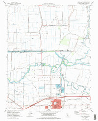
1978 Map of Union Island
USGS Topo · Published 1978About this map
Union Island is a complex landscape of reclaimed delta lands defined by an intricate network of levees, canals, and pumping stations in the late 1970s. The northern reaches are characterized by the Gas Field and schools like Delta Island Sch, while the southern portion transition into the growing outskirts of Tracy. This map captures the intersection of heavy hydraulic engineering and agriculture, where the Middle River and Old River navigate through the El Pescadero (Pico and Naglee) land grant. The presence of numerous Pumping Stations and specialized water features like the Industrial Waste Ponds and the Fabian and Bell Canal illustrates the intensive management required to maintain these low-lying tracts for industrial and residential use. From the Landing Strip on the island to the emerging neighborhoods like Larch Clover Park, the map documents a region in the midst of suburban expansion into traditional ranchlands.
Find a feature on this map
54 named features on this map. Tap any name to fly to it.
Don’t see what you’re looking for? This feature index may not catch every label — zoom into the map to look around manually.
Map Details
Editions of this 1978 Union Island Map
This is the sole edition of this map. No revisions or reprints were ever made.
Other maps of this area

1907 · Tesla
USGS Topo · 1:62,500

1913 · Woodward Island
USGS Topo · 1:31,680

1913 · Stockton
USGS Topo · 1:31,680

1913 · Holt
USGS Topo · 1:31,680

1914 · Bethany
USGS Topo · 1:31,680

1914 · Union Island
USGS Topo · 1:31,680

1915 · Vernalis
USGS Topo · 1:31,680

1915 · Lathrop
USGS Topo · 1:31,680

1916 · Byron
USGS Topo · 1:62,500

1916 · Tracy
USGS Topo · 1:31,680