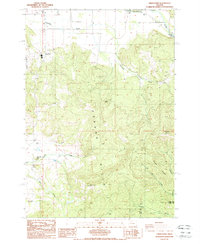
1988 Map of Union Point
USGS Topo · Published 1988About this map
Union Point sits at the northern edge of the Coburg Hills in this late-1980s Linn County survey. The landscape transitions from the flat agricultural plains of the Dinwiddie Valley into the steep, rising elevations of Bald Mountain and Diamond Hill. This area is characterized by a network of drainage systems, including the Calapooia River in the northeast and smaller tributaries like Courtney Creek, Tub Run, and White Creek.
Find a feature on this map
24 named features on this map. Tap any name to fly to it.
Don’t see what you’re looking for? This feature index may not catch every label — zoom into the map to look around manually.
Map Details
Editions of this 1988 Union Point Map
This is the sole edition of this map. No revisions or reprints were ever made.
Other maps of this area

1909 · Rowland
USGS Topo · 1:31,680

1910 · Eugene
USGS Topo · 1:62,500

1911 · Brownsville
USGS Topo · 1:31,680

1912 · Halsey
USGS Topo · 1:62,500

1921 · Brownsville
USGS Topo · 1:62,500

1940 · Eugene
USGS Topo · 1:62,500

1941 · Halsey
USGS Topo · 1:62,500

1946 · Eugene
USGS Topo · 1:62,500

1949 · Eugene
USGS Topo · 1:62,500

1950 · Marcola
USGS Topo · 1:62,500