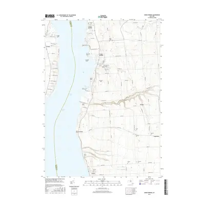
2016 Map of Union Springs
USGS Topo · Published 2016About this map
Cayuga Lake defines the western edge of this landscape, separating the shoreline of Seneca County from the lakeside villages of Cayuga County. The village of Union Springs serves as a focal point along the water, characterized by its grid of streets and numerous religious sites, including the Old Quaker Cem and Saint Michaels Roman Catholic Cem near Chestnut Hill Cem. Further south, the settlement of Aurora sits near the mouth of Glen Cr, where the Oak Glen Cem and Saint Patricks Cem mark the community's local heritage. The terrain is deeply etched by watercourses like Great Gully and Glen Cr, which cut eastward from the lake into the agricultural uplands. Smaller hamlets such as Levanna, Scipioville, and Bunker are linked by a network of rural routes, including Co Rte 46 and Co Rte 152, reflecting a long-standing pattern of lakeside development and inland farming.
Find a feature on this map
93 named features on this map. Tap any name to fly to it.
Don’t see what you’re looking for? This feature index may not catch every label — zoom into the map to look around manually.
Map Details
Editions of this 2016 Union Springs Map
This is the sole edition of this map. No revisions or reprints were ever made.
Other maps of this area

1899 · Auburn
USGS Topo · 1:62,500

1902 · Geneva
USGS Topo · 1:62,500

1902 · Genoa
USGS Topo · 1:62,500

1902 · Ovid
USGS Topo · 1:62,500

1902 · Auburn
USGS Topo · 1:62,500

1942 · Ovid
USGS Topo · 1:31,680

1942 · Sheldrake
USGS Topo · 1:24,000

1942 · Genoa
USGS Topo · 1:24,000
1943 · Genoa
USGS Topo · 1:31,680

1943 · Cayuga
USGS Topo · 1:31,680