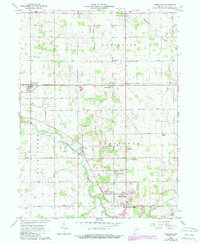
1962 Map of Uniondale
USGS Topo · Published 1988About this map
The Wabash River meanders through the central landscape of this Wells County survey, serving as a focal point for local organization between the settlements of Murray and the northern outskirts of Bluffton. A historical Treaty Line cuts diagonally across the northern townships, reflecting the early structural division of the land. The mapping reveals a well-established agricultural and civic network, with prominent features like the Lancaster Central Sch and the Murray Conservation Club anchoring the community. Transportation patterns are defined by a grid of rural roads and the remnant path of an Old Railroad Grade passing through Kingsland. To the south, the expansion of the county seat is evident near Toll Gate Heights and the Drive-in Theater, while smaller crossroads like Uniondale and Greenwood maintain their rural character amidst a network of drainage ditches such as Fleming Ditch and Griffin Ditch.
Find a feature on this map
35 named features on this map. Tap any name to fly to it.
Don’t see what you’re looking for? This feature index may not catch every label — zoom into the map to look around manually.
Map Details
Editions of this 1962 Uniondale Map
2 editions found
Other maps of this area

1953 · Muncie
USGS Topo · 1:250,000

1955 · Markle
USGS Topo · 1:24,000

1956 · Muncie
USGS Topo · 1:250,000
1961 · Zanesville
USGS Topo · 1:24,000

1962 · Poe
USGS Topo · 1:24,000

1962 · Uniondale
USGS Topo · 1:24,000

1962 · Ossian
USGS Topo · 1:24,000

1962 · Liberty Center
USGS Topo · 1:24,000

1962 · Preble
USGS Topo · 1:24,000

1962 · Linn Grove
USGS Topo · 1:24,000