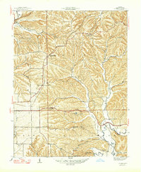
1947 Map of Unionville
USGS Topo · Published 1947About this map
Benton and Salt Creek townships are defined by a complex network of ridges and hollows in this 1944 survey. The Illinois Central railroad cuts through the north, serving Unionville and the dual-named New Unionville Unionville Sta.. This era captures a landscape of small, localized communities, each centered around essential rural institutions like the Poplar Grove Sch, Mt Gilead Ch, and Brummett Creek Ch.
Find a feature on this map
47 named features on this map. Tap any name to fly to it.
Don’t see what you’re looking for? This feature index may not catch every label — zoom into the map to look around manually.
Map Details
Editions of this 1947 Unionville Map
2 editions found
Other maps of this area

1908 · Bloomington
USGS Topo · 1:48,000

1910 · Bloomington
USGS Topo · 1:62,500

1942 · Franklin
USGS Topo · 1:125,000

1946 · Belmont
USGS Topo · 1:24,000

1947 · Allens Creek
USGS Topo · 1:24,000

1947 · Unionville
USGS Topo · 1:24,000

1947 · Elkinsville
USGS Topo · 1:24,000

1948 · Hindustan
USGS Topo · 1:24,000

1948 · Morgantown
USGS Topo · 1:24,000

1950 · Belmont
USGS Topo · 1:24,000