
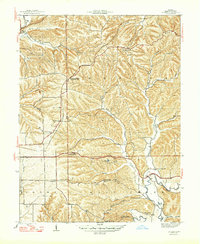
1947 Map of Unionville
USGS Topo · Published 1947About this map
The Illinois Central railroad defines the transportation corridor of this mid-century landscape, passing through New Unionville Unionville Sta as it traverses the ridges of Monroe County. The map captures a transition from the agricultural lowlands near Dolan to the deeply dissected terrain of the Benton and Salt Creek townships. A network of rural institutions is well-preserved here, including several country schools like Fleener Sch and Lampkin Sch, alongside churches such as Mt Gilead Ch and Brummett Creek Ch. Notable geographic landmarks include the narrow Devils Backbone ridge and a hilltop Observatory south of Radientown, highlighting the area's elevation and clear vantage points. The drainage patterns of Stephens Creek and the North Fork Salt Creek illustrate the natural topography that shaped early settlement and road placement throughout the region.
Find a feature on this map
49 named features on this map. Tap any name to fly to it.
Don’t see what you’re looking for? This feature index may not catch every label — zoom into the map to look around manually.
Map Details
Editions of this 1947 Unionville Map
2 editions found
Other maps of this area

1908 · Bloomington
USGS Topo · 1:48,000

1910 · Bloomington
USGS Topo · 1:62,500

1942 · Franklin
USGS Topo · 1:125,000

1946 · Belmont
USGS Topo · 1:24,000

1947 · Allens Creek
USGS Topo · 1:24,000

1947 · Elkinsville
USGS Topo · 1:24,000

1948 · Hindustan
USGS Topo · 1:24,000

1948 · Morgantown
USGS Topo · 1:24,000

1950 · Belmont
USGS Topo · 1:24,000

1950 · Morgantown
USGS Topo · 1:24,000