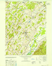
1953 Map of Unionville
USGS Topo · Published 1953About this map
The village of Unionville serves as the focal point for this survey of the New York and New Jersey borderlands, where the New York Susquehanna and Western railroad corridor supported local industry and commerce. Industrial sites such as the American Silk Label Co, Lewis Ringle Paper Co, and the Sussex Distillery highlight the manufacturing character of the region during the post-war era. The landscape transitions from the agricultural valley of the Wallkill River to the prominent heights of Pochuck Mountain in the southeast.
Find a feature on this map
47 named features on this map. Tap any name to fly to it.
Don’t see what you’re looking for? This feature index may not catch every label — zoom into the map to look around manually.
Map Details
Editions of this 1953 Unionville Map
This is the sole edition of this map. No revisions or reprints were ever made.
Other maps of this area

1888 · Franklin
USGS Topo · 1:62,500

1891 · Greenwood Lake
USGS Topo · 1:62,500

1893 · Greenwood Lake
USGS Topo · 1:62,500

1894 · Franklin
USGS Topo · 1:62,500

1897 · Franklin
USGS Topo · 1:62,500

1903 · Franklin Furnace
USGS Topo · 1:62,500

1903 · Greenwood Lake
USGS Topo · 1:62,500

1906 · Port Jervis
USGS Topo · 1:62,500

1906 · Goshen
USGS Topo · 1:62,500

1908 · Goshen
USGS Topo · 1:62,500