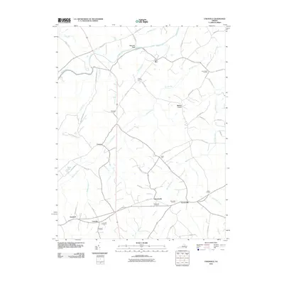
2010 Map of Unionville
USGS Topo · Published 2010About this map
Unionville and Rhoadesville anchor this northern Virginia landscape, where the Rapidan River forms the northern boundary. The terrain is defined by a dense network of tributaries including Mountain Run and Black Walnut Run, supporting a series of small, established settlements. This area is notably dense with family and community burial grounds, such as Palmyra Cemetery and Mount Holy Cemetery, which provide essential touchpoints for genealogical research. The road network, featuring names like Old Office Rd and Raccoon Ford Rd, reflects the agricultural and postal history of Orange County. From the junction at Verdiersville to the rural pockets of True Blue and Everona, the map records a traditional rural structure maintained into the early twenty-first century. This persistence of small-scale place names and church-affiliated landmarks like Mount Sinai Cemetery offers a detailed view of the regional social geography.
Find a feature on this map
58 named features on this map. Tap any name to fly to it.
Don’t see what you’re looking for? This feature index may not catch every label — zoom into the map to look around manually.
Map Details
Editions of this 2010 Unionville Map
This is the sole edition of this map. No revisions or reprints were ever made.
Other maps of this area

1887 · Spottsylvania
USGS Topo · 1:125,000

1892 · Spottsylvania
USGS Topo · 1:125,000

1892 · Gordonsville
USGS Topo · 1:125,000

1942 · Lahore
USGS Topo · 1:31,680

1942 · Belmont
USGS Topo · 1:31,680

1943 · Germanna Bridge
USGS Topo · 1:24,000

1943 · Culpeper
USGS Topo · 1:24,000

1943 · Mine Run
USGS Topo · 1:24,000

1943 · Unionville
USGS Topo · 1:24,000
1944 · Culpeper
USGS Topo · 1:31,680