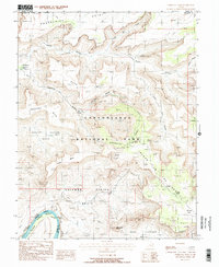
1988 Map of Upheaval Dome
USGS Topo · Published 1988About this map
Upheaval Dome dominates this portion of the Island in the Sky district, where the intricate drainage systems of Taylor Canyon and the Upheaval Pack illustrate the geological complexity of the High Desert. This 1980s-era mapping of Canyonlands National Park provides a detailed look at the recreational infrastructure and landmarks established by the late 20th century, including the Upheaval Picnic Area and the Upheaval Bottom Campground. In the southwest corner, the Green River carves through Stillwater Canyon, revealing the stark elevation changes between the river basin and landmarks like Candlestick Tower and Zeus and Moses. The map documents numerous footpaths, such as the Taylor Foot Trail, which connect high mesas like Buck Mesa to deep depressions like Potato Bottom Basin.
Find a feature on this map
31 named features on this map. Tap any name to fly to it.
Don’t see what you’re looking for? This feature index may not catch every label — zoom into the map to look around manually.
Map Details
Editions of this 1988 Upheaval Dome Map
This is the sole edition of this map. No revisions or reprints were ever made.
Other maps of this area

1885 · San Rafael
USGS Topo · 1:250,000

1885 · La Sal
USGS Topo · 1:250,000

1951 · The Knoll
USGS Topo · 1:62,500

1951 · Upheaval Dome
USGS Topo · 1:62,500

1952 · Tidwell 4 SE
USGS Topo · 1:24,000

1952 · Carlisle 2 SE
USGS Topo · 1:24,000

1952 · Carlisle 2 NW
USGS Topo · 1:24,000

1952 · Moab 3 SE
USGS Topo · 1:24,000

1952 · Carlisle 2 NE
USGS Topo · 1:24,000

1952 · Carlisle 2 SW
USGS Topo · 1:24,000