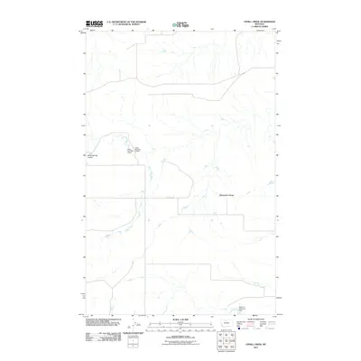
2011 Map of Uphill Creek
USGS Topo · Published 2011About this map
Riverview Colony stands as a focal point of human settlement in this stretch of Liberty County, Montana, representing a distinct Hutterite community and agricultural way of life. The landscape is defined by the winding course of Uphill Creek, which meanders northward through the heart of the terrain. The management of water in this semi-arid environment is evident through several localized infrastructure projects, specifically State Number 2 Dam, State Number 3 Dam, and the Roamin' Reservoir Dam located in the southeastern corner. These features, along with the Alkali Springs Coulee and the traverse of Dugout Rd, illustrate the intersection of natural drainage patterns and the rural road and irrigation networks that sustain local farming and ranching operations.
Find a feature on this map
8 named features on this map. Tap any name to fly to it.
Don’t see what you’re looking for? This feature index may not catch every label — zoom into the map to look around manually.
Map Details
Editions of this 2011 Uphill Creek Map
This is the sole edition of this map. No revisions or reprints were ever made.
Other maps of this area

1954 · Shelby
USGS Topo · 1:250,000

1958 · Shelby
USGS Topo · 1:250,000

1970 · Circle Bridge
USGS Topo · 1:24,000

1970 · Carlson Coulee
USGS Topo · 1:24,000
1970 · Dorner School
USGS Topo · 1:24,000

1970 · Uphill Creek
USGS Topo · 1:24,000

1970 · Goose Bill Butte NW
USGS Topo · 1:24,000
1970 · Russell Chapel
USGS Topo · 1:24,000
1970 · Mc Bridy Spring
USGS Topo · 1:24,000

1970 · Lothair SW
USGS Topo · 1:24,000
Featured Places
- Riverview Hutterite Colony, MT
- Riverview Colony, MT
- Chouteau County, MT
- Liberty County, MT
- United States