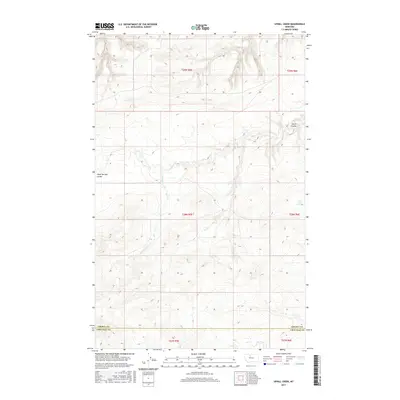
2017 Map of Uphill Creek
USGS Topo · Published 2017About this map
Uphill Creek meanders through the high plains of north-central Montana, carving a complex system of drainages across the boundary between Liberty and Chouteau counties. This landscape is defined by the erosion patterns of Alkali Springs Coulee and Basin Coulee, which cut through the undulating prairie. The map illustrates a section of the American West where the Public Land Survey System creates a rigid grid over a fluid natural geography. The township and range lines, including t29n r5e and t28n r6e, provide a framework for understanding the sparse settlement and agricultural partitioning of this vast ranching and dry-farming territory. The topographical detail reveals the subtle elevation changes that dictate water movement toward the Missouri River basin to the south.
Find a feature on this map
10 named features on this map. Tap any name to fly to it.
Don’t see what you’re looking for? This feature index may not catch every label — zoom into the map to look around manually.
Map Details
Editions of this 2017 Uphill Creek Map
This is the sole edition of this map. No revisions or reprints were ever made.
Other maps of this area

1954 · Shelby
USGS Topo · 1:250,000

1958 · Shelby
USGS Topo · 1:250,000

1970 · Circle Bridge
USGS Topo · 1:24,000

1970 · Carlson Coulee
USGS Topo · 1:24,000
1970 · Dorner School
USGS Topo · 1:24,000

1970 · Uphill Creek
USGS Topo · 1:24,000

1970 · Goose Bill Butte NW
USGS Topo · 1:24,000
1970 · Russell Chapel
USGS Topo · 1:24,000
1970 · Mc Bridy Spring
USGS Topo · 1:24,000

1970 · Lothair SW
USGS Topo · 1:24,000
Featured Places
- Riverview Hutterite Colony, MT
- Riverview Colony, MT
- Chouteau County, MT
- Liberty County, MT
- United States