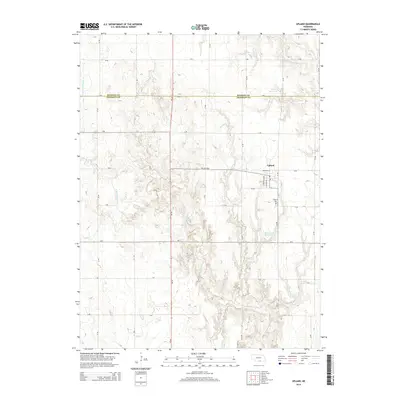
2014 Map of Upland
USGS Topo · Published 2014About this map
Upland sits at the intersection of rural agriculture and northern Franklin Co, marking a transition from the plains into the rolling drainage of the Little Blue River. This 2014 survey captures a landscape defined by an orderly grid of section roads like Ne-4 and Ne-10, which navigate the draws and ridges shaped by the W Br Thompson Cr. The town of Upland itself is the primary settlement, supported by local infrastructure such as the Upland Cem and residential streets like S Greenfield Ave. Significant water management features, including Olson Reservoir and Bertrand Reservoir, emphasize the importance of water storage in this section of the Great Plains. The boundary between Kearney Co and Franklin Co bisects the northern reach of the map, illustrating the administrative divisions of this Nebraska heartland.
Find a feature on this map
21 named features on this map. Tap any name to fly to it.
Don’t see what you’re looking for? This feature index may not catch every label — zoom into the map to look around manually.
Map Details
Editions of this 2014 Upland Map
This is the sole edition of this map. No revisions or reprints were ever made.
Other maps of this area

1896 · Holdrege
USGS Topo · 1:125,000

1897 · Red Cloud
USGS Topo · 1:125,000

1955 · Grand Island
USGS Topo · 1:250,000

1957 · Grand Island
USGS Topo · 1:250,000

1958 · Grand Island
USGS Topo · 1:250,000

1969 · Upland
USGS Topo · 1:24,000

1969 · Upland SE
USGS Topo · 1:24,000
1969 · Norman
USGS Topo · 1:24,000
1969 · Minden South
USGS Topo · 1:24,000
1970 · Axtell East
USGS Topo · 1:24,000